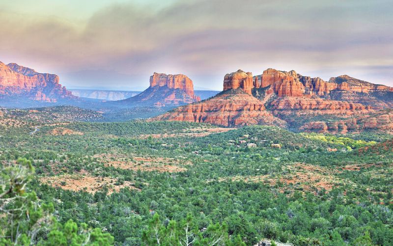
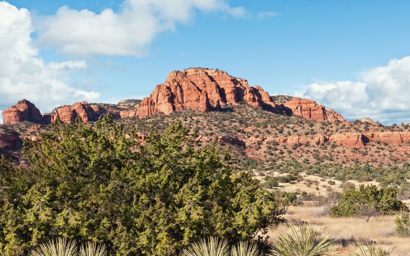
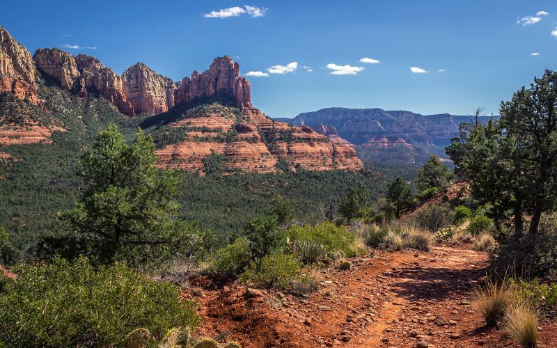
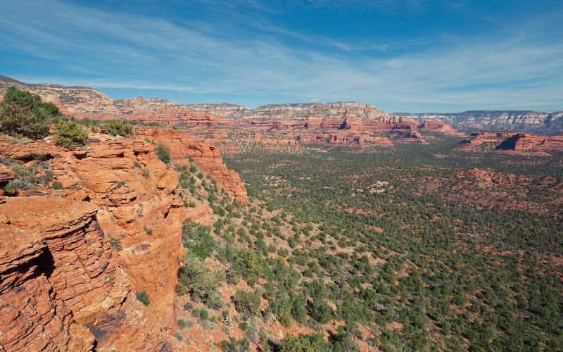
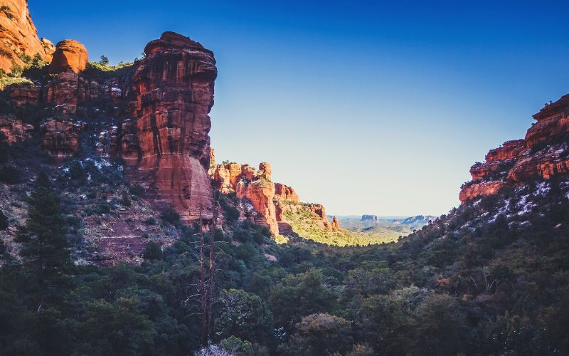
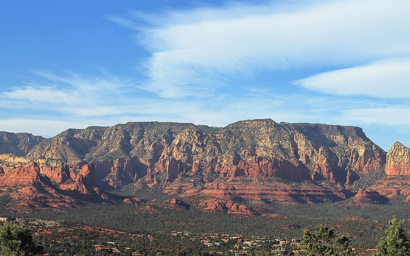
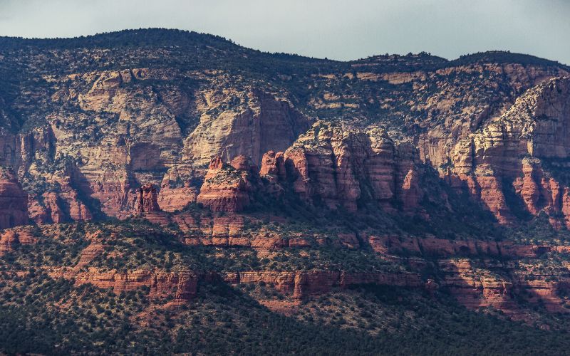
If you can’t decide where to begin your next Sedona adventure then you are not alone! The famous red rock and majestic canyons of Sedona have over 400 miles of hiking trails, from ridges with fantastic lookouts to deep forest trails, there’s a trail here for every type of hiker!
Surrounded by 1.8 million acres of national forest land, stunning red rocks, and scenic canyons, Sedona is the ultimate spot to get outdoors and spend some time with your family and friends (or your thoughts!). Our list has a hike to suit everyone’s taste and is followed by our top tips to make the most out of your trip.
Do
Don’t

Table of Contents
- Ready For the Best Sedona Hikes?
- 1. Cathedral Rock Trail
- 2. Wilson Canyon Trail
- 3. Devil’s Bridge Trail
- 4. Bear Mountain Trail
- 5. Birthing Cave
- 6. Brins Mesa And Soldier Pass Trail Loop
- 7. Doe Mountain Trail
- 8. Bell Rock Pathway
- 9. Fay Canyon Trail
- 10. Munds Wagon Trail to Merry Go Round Rock
- 11. Boynton Canyon Trail
- 12. Courthouse Butte Loop Trail
- 13. Airport Mesa Trail
- 14. West Fork Trail (Via Oak Creek Trail)
- 15. Mescal Trail
- What Are Some Hiking Tips For Sedona?
- Which Sedona Hiking Trails Will You Tackle First?
| Trail Name | Type | Difficulty | Distance | Duration | Elevation Gain |
|---|---|---|---|---|---|
| Cathedral Rock Trail | Out and back | Moderate | 1.2 miles | 1 hour | 741 ft |
| Wilson Canyon Trail | Out and back | Challenging | 3.2 miles | 1.5 hours | 394 ft |
| Devil’s Bridge Trail | Out and back | Moderate | 4.2 miles | 2 hours | 522 ft |
| Bear Mountain Trail | Out and back | Challenging | 4.9 miles | 4–5 hours | 2020 ft |
| Birthing Cave | Out and back | Easy | 2 miles | 1 hour | 243 ft |
| Brins Mesa And Soldier Pass Trail Loop | Loop | Moderate | 6 miles | 2.5 hours | 920 ft |
| Doe Mountain Trail | Out and back | Moderate | 1.4 miles | 45 mins | 512 ft |
| Bell Rock Pathway | Out and back | Easy | 3.6 miles | 2.5 hours | 350 ft |
| Fay Canyon Trail | Out and back | Easy | 2.4 miles | 1.5 hours | 295 ft |
| Munds Wagon Trail To Merry Go Round Rock | Out and Back | Moderate | 6.5 miles | 3 hours | 1100 ft |
| Boynton Canyon Trail | Out and back | Moderate | 7.2 miles | 3–3.5 hours | 965 ft |
| Courthouse Butte Loop Trail | Loop | Moderate | 2.7 miles | 2 hours | 345 ft |
| Airport Mesa Trail | Loop | Easy | 3.3 miles | 1.5 hours | 425 ft |
| West Fork Trail (Via Oak Creek Trail) | Out and back | Moderate | 6.5 miles | 3 hours | 560 ft |
| Mescal Trail | Out and back | Easy | 2.4 miles | 1 hour | 377 ft |
Ready For the Best Sedona Hikes?
Check out the following list of our favorite hikes in Sedona, Arizona to help you discover this magical place. You can start your adventure with a visit to the picturesque Cathedral Rock, offering stunning views of the surrounding red rock formations. Then, make your way to the iconic Devil’s Bridge, a natural sandstone arch that provides the perfect photo opportunity. For even more outdoor exploration, be sure to explore Tucson’s top hiking spots, which offer a wide variety of trails for all skill levels. Whether you’re a seasoned hiker or a beginner, Sedona has something for everyone to enjoy.
- Cathedral Rock Trail
- Wilson Canyon Trail
- Devils Bridge Trail
- Bear Mountain Trail
- Birthing Cave
- Brins Mesa and Soldiers Pass Trail Loop
- Doe Mountain Trail
- Bell Rock Pathway
- Fay Canyon Trail
- Munds Wagon Trail to Merry Go Round Rock
- Boynton Canyon Trail
- Courthouse Butte Loop Trail
- Airport Mesa Trail
- West Fork Trail (via Oak Creek Trail)
- Mescal Trail
1. Cathedral Rock Trail
The Cathedral Rock Trail is one of the Sedona area’s best short hikes. Despite being a little over a mile, it provides a quad-busting challenge and sumptuous views.
This 1.2-mile hike is situated in Coconino National Forest and involves 500ft of elevation gain. While considered moderate, it does involve a touch of rock scrambling and will take around an hour to complete.
The trailhead for the Cathedral Rock Trail is on Back O Beyond Road. If you don’t manage to snag a parking space here, start from the Baldwin Trailhead instead. It’s a bit of a walk to the trailhead, but you’ll warm up your legs for the steep, slick climb that awaits! The hike is never too taxing, but there are a few steep sections. The jaw-dropping views you’ll find at the top, however, are well worth the effort.
Parking is available near the trailhead Monday through Wednesday. From Thursday through Sunday, you’ll have to leave your vehicle at the park and ride at 1294 SR 179 and take the Sedona Shuttle to the trailhead. This is one of the most popular Sedona trails, so don’t expect much solitude. Dogs are allowed on the trail.
You can easily extend your hike by hopping onto the Templeton Trail or Easy Breezy Trail, both of which will let you enjoy a full day out, depending how far along them you choose to go.
- Type: Out and back
- Difficulty: Moderate
- Estimated Duration: 1 hour
- Distance: 1.2 miles / 1.9 km
- Elevation Gain: 226 m/741 ft.
- Trailhead Location: Back’O’Beyond Road
- Parking: Back’O’Beyond Road (Mon-Wed only). Thu-Sun use Sedona Shuttle service from park and ride at 1294 SR 179.
- Dogs: Yes.
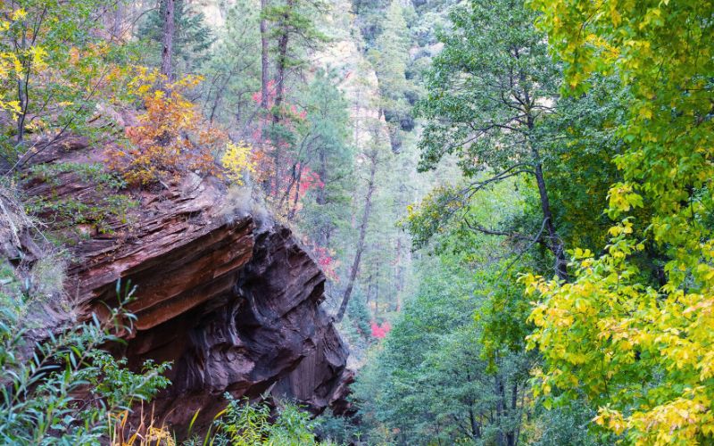
2. Wilson Canyon Trail
The Wilson Canyon Trail is one of the Sedona area’s most scenic hikes, serving up stunning views every step of the way.
This 3.2-mile out-and-back trail has under 400 feet of elevation gain, but is considered moderately challenging due to the spot of rock scrambling you’ll have to do along the way.
You’ll find the trailhead just north of Midgley Bridge on the left. The trail zig-zags across the canyon before revealing the stunning, red rock views near the end. There are two ways to the top of Wilson Mountain. The North Wilson Trail is the longer and more challenging of the two, but it offers better panoramas. The second, the Wilson Canyon Trail, is slightly shorter yet still scenic.
Parking is available at Midgley Bridge (Red Rock Pass required). Dogs are allowed but must be leashed.
The peak earned its name from Richard Wilson, an ill-fated huntsman and trapper who had an unfortunate encounter with a grizzly in the canyon that now “bears” his name. Just remember, black bears can still be spotted along the trail. It wouldn’t hurt to freshen up on bear safety to avoid Wilson’s fate!
- Type: Out and back
- Difficulty: Challenging
- Estimated Duration: 1.5 hours
- Distance: 3.2 miles/4.3 km
- Elevation Gain: 120m/394 ft.
- Trailhead Location: The picnic ramada near the Midgley Bridge parking area.
- Parking: At the north end of Midgley Bridge.
- Dogs: Yes (leashed).
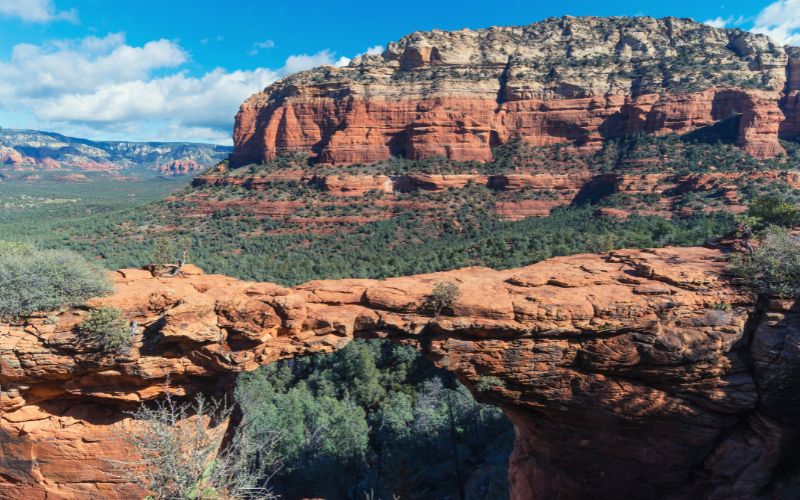
3. Devil’s Bridge Trail
The Devil’s Bridge Trail is widely regarded as the best hike in Sedona for thrill-seekers thanks to the opportunity to walk (or crawl!) over the massive natural arch at the trail’s end.
Despite a 400ft climb, this 4.2-mile out-and-back trail is one of the best hikes Sedona has to offer novice hikers. The trail is easy most of the way and it will take you just 2 hours round trip even at a moderate pace.
The trail starts at the parking lot off Dry Creek Road and well-visible trail markers will guide your way for the entire ascent. The first half of the trail is wide and easy to follow but becomes quite narrow and steep as you make your way towards the arch, which is one of the most stunning sights to be seen in the state as a whole, let alone the Sedona area.
If you have the courage, you can even walk your way across the arch. Just don’t look down and be sure to wear hiking boots with good grip!
Parking is available at the trailhead if you have a high-clearance vehicle, otherwise you’ll have to park at the end of the unpaved section of Dry Creek Road and add one mile to your journey. Dogs are allowed but must be leashed.
To extend your day’s hiking, you can hop onto various other trails nearby, including the Thunder Mountain Trail, Brins Mesa Trail, and the Chimney Rock Trail, all of which will give you a full day out and let you see plenty more stunning rock formations!
- Type: Out and back
- Difficulty: Moderate
- Estimated Duration: 2 hours
- Distance: 4.2 miles/6.3 km
- Elevation Gain: 159m/522 ft.
- Trailhead Location: Dry Creek Road.
- Parking: Low-clearance vehicles – Dry Creek Road trailhead at the end of the paved section of road or at the Mescal Trailhead on Long Canyon Road. High-clearance vehicles – 1.3 miles down the unpaved section of Dry Creek Road.
- Dogs: Yes (leashed).
4. Bear Mountain Trail
The hike to the top of Bear Mountain is one of Sedona’s most challenging trails, and also one of its most rewarding.
This 4.9-mile out-and-back trail is located just a ten-minute drive north of the city. It takes 4–5 hours and you’ll face over 1,800ft in elevation gain. This trail is technically challenging too – expect lots of steep sections and rock scrambling!
Start from the parking lot on Boynton Pass Road. The trail steadily gains elevation passing desert cacti, juniper trees, and plenty of red rock along the way. Soon, things get a little more vertical and you’ll have earned your lunch after the steep slog to the summit. Conquer this thigh-busting trek, however, and you’ll be rewarded with 360-degree views of Sedona’s beautiful red rock scenery.
Parking is available on Boynton Pass Road, either roadside or in the trailhead parking lot. Dogs are allowed but must be leashed. This is a particularly busy trail, so arrive early to snag a parking space!
When you’re done, you can cross the road and head up the Doe Mountain Trail to make the most of your day out – if, that is, you have enough gas left in the tank!
- Type: Out and back
- Difficulty: Challenging
- Estimated Duration: 4–5 hours
- Distance: 4.9 miles/7.9 km
- Elevation Gain: 615m/2020 feet
- Trailhead Location: Parking area on FR 152C.
- Parking: Boynton Pass Road.
- Dogs: Yes (leashed).
5. Birthing Cave
The Birthing Cave trail allows you to hike to one of Sedona’s most storied and spectacular landmarks – a hidden cave nestled in the cliffs over the city.
This west Sedona trail is a 19-mile out-and-back with under 300 ft of elevation gain, so it’s ideal if you’re looking for easy or kid-friendly hiking in Sedona.
Start from the Long Canyon Trailhead off of Long Canyon Road. From here, follow the Long Canyon Trail for 0.6 miles on a nice, wide path before turning left for the final 0.3/4 miles to the cave. The trail has poor cell reception and the trail markers aren’t always obvious, so download or bring a map before you head out.
Parking is available at the Long Canyon trailhead or the Mescal Trailhead (add 0.5 miles each way). Dogs are allowed but must be leashed. You don’t need a Red Rock Pass to hike in the area.
The Birthing Cave is believed to have earned its unique name from the belief that local Hopi women once visited this cave to give birth to their children. An equally compelling theory maintains that the cave resembles the female genitalia. Either way, this giant red-rock notch is quite the spectacle!
- Type: Out and back
- Difficulty: Easy
- Estimated Duration: 1 hour
- Distance: 2 miles/3.2km
- Elevation Gain: 74m/243ft
- Trailhead Location: Long Canyon Trailhead off of Long Canyon Road
- Parking: Long Canyon Trailhead on Long Canyon Road or on the shoulder of Long Canyon Road
- Dogs: Yes (leashed).
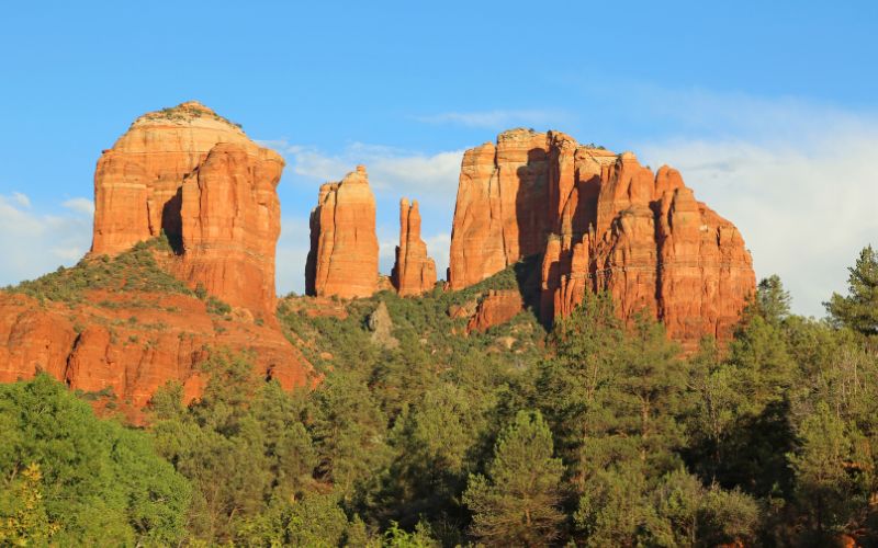
6. Brins Mesa And Soldier Pass Trail Loop
The Brins Mesa and Soldier Pass Trail Loop is one of Sedona’s hidden-gem backcountry trails. While they might not offer the same epic views as some of the more popular hikes in the area, they’re still worth visiting, especially if you’re looking to enjoy a bit of solitude.
This 6-mile loop involves over 900 feet of elevation gain and is moderately challenging. It takes most hikers 2 to 3 hours to complete.
We suggest taking the loop clockwise starting with the Soldier Pass Trail. That way, you can hike the more popular and crowded Soldier Pass Trail early on in the day and hopefully reach the stunning caves and the seven sacred pools before they become too crowded. Then, you’ll be able to enjoy the quieter Brins Mesa Trail later on in the day.
Parking is available at the Brins Mesa Trailhead on FR 633. Dogs are welcome but must be leashed. You’ll need a Red Rock Pass for this one – you can buy yours at the machine at the trailhead.
To reach Soldier Pass Cave, the trail’s most interesting cave, you’ll need to take a spur trail from just below Soldier Pass. This will add 0.4 miles to your trip, but it’s well worth it!
- Type: Loop
- Difficulty: Moderate
- Estimated Duration: 2.5 hours
- Distance: 6 miles/9.7 km
- Elevation Gain: 280m/920ft.
- Trailhead Location: The end of Forest Service 9904 Road.
- Parking: Parking lot at end of Forest Service 9904 Road.
- Dogs: Yes (leashed).
7. Doe Mountain Trail
The Doe Mountain Trail is perhaps the best trail in Sedona for hikers looking for a quick workout that serves up perfect panoramas.
This 1.4-mile out-and-back trail involves 400 feet of elevation gain and takes just 45 minutes to complete, but the trail is steep and quickly transports you onto a large plateau with incredible views of almost all of the area’s famed red rocks.
Starting from the parking lot on FR 152C, the wide and open path winds gently through scrub before turning steep as you approach the base of the mountain. Expect to see lots of Arizona’s local wildlife like rabbits, scorpions, and other critters on the way. A touch of scrambling is required to reach the top, so you’ll have to watch your footing when the rock is wet. Reliable hiking boots are a must, while hiking poles are recommended.
Limited parking is available at the trailhead, for which you’ll need a Red Rock Pass. Dogs are allowed but must be leashed.
The DMT shares a trailhead with the Beat Mountain Trail, so you can tick off two iconic Sedona hikes in a day if you have the energy!
- Type: Out and back
- Difficulty: Moderate
- Estimated Duration: 45 mins
- Distance: 1.4 miles/2.25km
- Elevation Gain: 156m/512 ft.
- Trailhead Location: Parking lot on Forest Service Road 152C.
- Parking: Forest Service Road 152C
- Dogs: Yes (leashed).
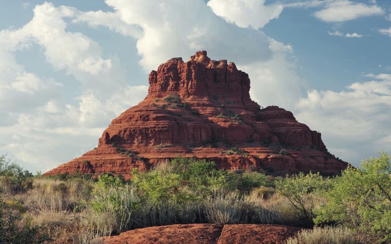
8. Bell Rock Pathway
Bell Rock Pathway is one of the most popular hikes in Sedona thanks to its instantly recognizable mascot, a bell-shaped rock formation.
You can do this hike as an out-and-back or walk it point-to-point between the village of Oak Creek and the city of Sedona. The out-and-back is 3.6 miles with 350 feet of elevation gain and takes around 2–2.5 hours.
Starting at the Bell Rock Vista trailhead, the majority of the trail is wide and flat with few steep hills, making it the perfect trek for families. Along the way, you’ll enjoy fantastic views of not only Bell Rock as you approach, but Courthouse Butte and other natural landmarks. The Bell Rock Pathway does not actually circle the base of Bell Rock – for that, you’ll have to venture down a side trail.
Parking is available one mile North of the South Gateway Visitor Center. A Red Rock Pass is required. Dogs are allowed but must be leashed.
There are myriad spurs and neighboring trails you can take to extend this hike. Our favorites include the Courthouse Butte Loop and Broken Arrow Trail.
- Type: Out and back
- Difficulty: Easy
- Estimated Duration: 2.5 hours
- Distance: 3.6 miles/5.8 km
- Elevation Gain: 107m/350ft.
- Trailhead Location: Southern trailhead – 1 mile north from the South Gateway Visitor Center to Bell Rock parking area. Northern trailhead – milepost 309.8 on 179 south.
- Parking: See above.
- Dogs: Yes (leashed).
9. Fay Canyon Trail
The Fay Canyon Trail is one of Sedona’s best hikes for families or casual hikers due to its short distance, minimal elevation gain, and gorgeous scenery.
This 2.4-mile trail has only 295 feet of elevation gain and takes 1.5 hours to complete.
The trail begins at the Boynton Pass parking lot on Boynton Pass Road. You’ll find nothing but a well-maintained and wide trail the entire way, giving you the perfect opportunity to admire the red sandstone canyon walls that line the path. Many hike this trail to check out the Fay Canyon arch, but it’s easy to miss. As you near the end, keep your eyes glued to the north (the right-hand side of the trail)!
Parking is available at the trailhead (Red Rock Pass not required). Dogs are allowed but must be leashed.
From the same parking area, you can extend your day out by jumping on the Bear Mountain Trail, Doe Mountain Trail, or Boynton Canyon Trail. Just make sure you have plenty of water and get there early to snag that parking spot!
- Type: Out and back
- Difficulty: Easy
- Estimated Duration: 1.5 hours
- Distance: 2.4 miles/3.9km
- Elevation Gain: 90m/295ft.
- Trailhead Location: Boynton Pass Road parking lot.
- Parking: Boynton Pass Road.
- Dogs: Yes (leashed).
10. Munds Wagon Trail to Merry Go Round Rock
The Mounds Wagon Trail to Merry Go Round Rock trail is the perfect Sedona hike for anyone keen to get off the beaten track.
This out-and-back trail is 6.5 miles long with over 1000 feet of elevation gain. It takes most hikers around 3 hours to complete.
Fresh air, bright blue skies, and impressive red rock views await you as you loop around Merry Go Round Rock. While this loop trail is fairly short, you’ll still need an ATV or a high-clearance 4×4 vehicle to get there. The road is windy and bumpy and people frequently end up turning back.
The Munds Wagon trail begins at the Huckaby/Munds Wagon Trailhead at the end of FR 153. You can cut the length of your hike to 1.4 miles (round trip) by driving down the Munds Wagon Trail to nearer the base of Merry Go Round Rock. However, you’ll need a high-clearance vehicle and miss the unfolding views of Pointed Dome, the Teapot, and Merry Go Round Rock itself.
Parking is available at the end of FR 153 (Red Rock Pass required – pay station at trailhead). Dogs are allowed but must be leashed.
The trail connects to the Schnebly Hill Trail, Margs Draw Trail, and Huckaby Trail, so there are options to extend your day’s hiking if you have the legs for it!
- Type: Out and Back
- Difficulty: Moderate
- Estimated Duration: 3 hours
- Distance: 6.5 miles/10.5 km
- Elevation Gain: 335m/1100ft (or
- Trailhead Location: Huckaby/Munds Wagon Trailhead at end of FR 153.
- Parking: Munds Wagon Trailhead parking lot, FR 153.
- Dogs: Yes (leashed).
11. Boynton Canyon Trail
The Boynton Canyon Trail is a mellow hike through one of Sedona’s most beautiful box canyons and famed energy vortices.
This 7.2-mile trail has nearly 1000 feet of elevation gain and takes around 3 hours to complete. The majority of the hike is on a flat trail but a short climb takes you to a viewpoint with incredible views of Boynton Canyon and Mescal Mountain.
Setting off from the parking area just off Forest Road 152BAs, the trail winds through a pleasant piñon forest that offers some respite when the sun’s out. The second half takes you up to a lovely viewpoint from where you’ll be surrounded by towering Coconino sandstone cliffs.
Parking is available at the trailhead (Red Rock Pass required). Dogs are allowed but must be leashed.
If you want to check the vortex out, at the trailhead take a detour down the side trail called the Boynton Vista Trail. There are two more memorable landmarks along the trail that you can visit: the Sinagua ruins and Subway Cave. Keep an eye out for signage marking the side trails that will take you out to these landmarks.
- Type: Out and back
- Difficulty: Moderate
- Estimated Duration: 3–3.5 hours.
- Distance: 7.2 miles/11.6km
- Elevation Gain: 295m/965ft
- Trailhead Location: Parking area just off Forest Road 152B.
- Parking: Forest Road 152B
- Dogs: Yes (leashed).
12. Courthouse Butte Loop Trail
Courthouse Butte and Bell Rock Loop Trail is a mellow hike that lets you see two of Sedona’s most recognizable rock formations up close and personal.
This 2.7-mile loop involves just 345 feet of elevation gain and is easy-going most of the way, making it a good option for families. Even at a moderate pace, it should take a maximum of two hours to complete.
There are two ways to access Courthouse Butte. From the south, you can take Bell Rock Pathway until its signed intersection with the Courthouse Butte Loop. From the North, follow along the Courthouse Vista trail heading towards Bell Rock until the trail intersects with the Bell Rock Pathway.
This majestic red rock rises over 1,000ft in the air, making it one of the most imposing landmarks in the area. The trek to get there will have you traversing the breathtaking Mogollon Rim – a unique, 200-mile-long limestone and granite cliff that stretches from Eastern Arizona to New Mexico.
Parking is available at the Courthouse Vista parking area (Red Rock Pass required). Dogs are allowed but must be leashed.
- Type: Loop
- Difficulty: Moderate
- Estimated Duration: 2 hours
- Distance: 2.7 miles/5.8km
- Elevation Gain: 105m/345ft.
- Trailhead Location: Courthouse Vista parking area off Red Rock Scenic Byway.
- Parking: Courthouse Vista parking area
- Dogs: Yes (leashed).
13. Airport Mesa Trail
The Airport Mesa Trail (or Airport Loop) is the best Sedona trail for hikers who are short on time but want to sample some spectacular views of the red rock cliffs for which the area is famed.
This easy, 3.3-mile trail begins off FR 660, northeast of the airport. It skirts along the edge of a shrub-covered mesa allowing you to enjoy the mesmerizing views from high above the valley. Although the trail is relatively flat, you’ll be exposed to the sun most of the way. Pack proper sun protection and enjoy spotting Sedona’s famous landmarks along the way, including Bell Rock, Cathedral Rock, and Thunder Mountain.
Parking is available at the trailhead (no pass required). Dogs are allowed but must be leashed.
- Type: Loop
- Difficulty: Easy
- Estimated Duration: 1.5 hours
- Distance: 3.3 miles/5.3km
- Elevation Gain: 130m/425ft.
- Trailhead Location: Parking lot on Airport Road
- Parking: Airport Road
- Dogs: Yes (leashed).
14. West Fork Trail (Via Oak Creek Trail)
The West Fork Trail is the perfect Sedona hike if you want to escape the sun and spend a day wandering in an enchanted-feeling canyon in the shade of tall trees and cliffs.
This 6.5-mile out-and-back hike has just 560 feet of elevation gain and is rarely strenuous. It takes most hikers 3 hours to complete, but there are plenty of places to take a timeout and chill in the shade if you want to make a day of it. The trail itself is easy to walk, although you will have to navigate across a couple of streams.
The trail begins at the West Fork Trailhead, just off the 89A. Parking is available but a Red Rock Pass is required. Dogs are permitted but must be leashed.
If you want to extend your trek, at the end of the trail you can continue towards the beautiful Red Rock Secret Mountain Wilderness.
- Type: Out and back
- Difficulty: Moderate
- Estimated Duration: 3 hours
- Distance: 6.5 miles/10.5km
- Elevation Gain: 170m/560ft.
- Trailhead Location: West Fork Trailhead, Shady Lane, just off the 89A.
- Parking: Shady Lane, just off the 89A.
- Dogs: Yes (leashed).
15. Mescal Trail
The Mescal Trail is one of our favorite Sedona hikes for families due to its short distance and minimal elevation gain.
This 2.4-mile hike involves just under 400 feet of elevation gain and takes around an hour to complete.
You’ll find the trailhead off of Long Canyon Road. For most of your trip, you’ll be traveling along open, slick rock. If you’re visiting in the spring, look out for the ocotillo in bloom and other dainty desert flowers. Also make sure you keep an eye out for the mountain bikes that regularly zoom by.
Parking is available at the trailhead on Long Canyon Road (Red Rock Pass required). Dogs are allowed but must be leashed.
Looking for something a bit more challenging? Try combining your trek with a detour to Deadman’s Pass or a trip to Boynton Canyon.
- Type: Out and back
- Difficulty: Easy
- Estimated Duration: 1 hour
- Distance: 2.4 miles/3.9km
- Elevation Gain: 115m/377ft
- Trailhead Location: Parking lot on Long Canyon Road
- Parking: Long Canyon Road
- Dogs: Yes (leashed).
What Are Some Hiking Tips For Sedona?
Below we’ve listed some tips to ensure you enjoy our favorite Sedona hikes happily and safely.
- Sedona is a very popular hiking spot. Parking lots fill up fast! Arrive early or plan for alternate transportation to and from the trailhead.
- You need a Red Rock Pass when hiking on National Forest Land in Red Rock Country. Purchase a Red Rock Pass and display it on your windshield to avoid a citation.
- Stay hydrated and eat often. When hiking in a desert climate like Arizona, your body consumes a lot of resources to stay cool. Bring along at least 1 liter of water for every 2 hours of hiking.
- Eat adequate amounts of food to ensure you’re replacing your electrolytes. In hot weather, drinking water without replacing the electrolytes you sweat out can lead to a dangerous condition known as hyponatremia. A good rule of thumb is to consume roughly 300 calories for every hour of hiking.
- Download or purchase a map before heading out. Many of the best Sedona trails are outside of the cell service area.
- Many Sedona trails are fully exposed. Make sure you come prepared for hot weather hiking and learn the signs of heat exhaustion.
Which Sedona Hiking Trails Will You Tackle First?
With its majestic red rock and the trails that traverse them, isn’t it about time you head to Sedona for a bit of hiking?
You don’t have to worry about your hiking expertise either! As long as you come prepared for hiking in hot weather, Sedona’s otherworldly terrain offers hikes suitable for hikers of all ability levels.
We hope you’ve enjoyed our guide. If you have any questions about hiking in the Grand Canyon state, feel free to drop us a line below. See ya on the trails!
We hope you’ve enjoyed our guide. If you have any questions about hiking in the Grand Canyon state, feel free to drop us a line below. See ya on the trails!