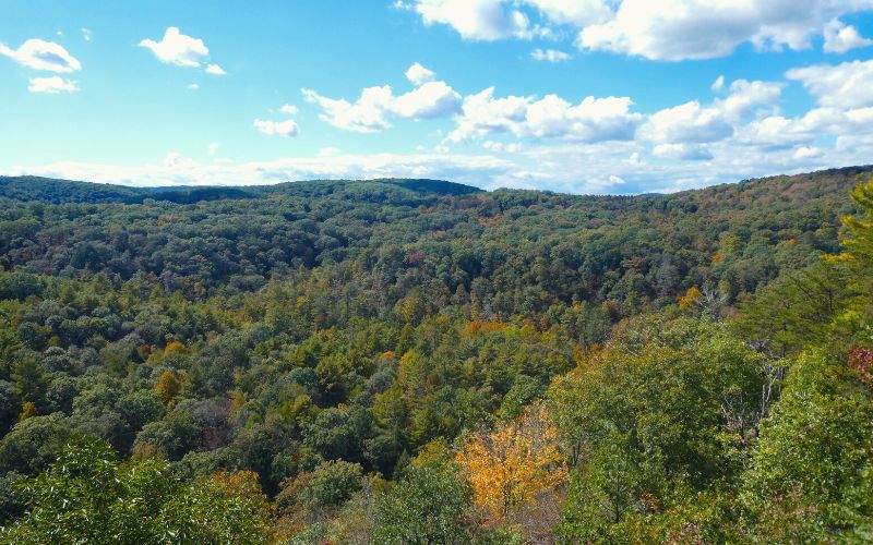
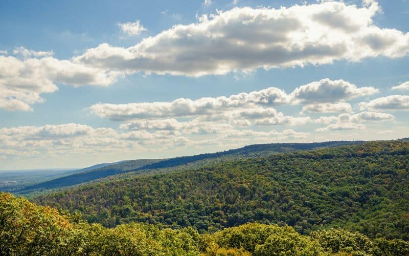
With its sloping mountains, lush woodlands, and incredible coastline, Maryland boasts a diverse range of landscapes and natural wonders ripe for exploring.
Whether you’re strolling along the historic Chesapeake & Ohio Canal or trekking through the picturesque Patapsco Valley, the Free State is a premiere destination for nature lovers and hikers of all skill levels.
This guide to Maryland’s top trails covers everything you need to know about the Free State’s top hikes, including descriptions and important details about each one.
Table of Contents
- 1. Swallow Falls Canyon Trail (Muddy Creek Falls), Swallow Falls State Park
- 2. Billy Goat Trail
- 3. Annapolis Rock (Appalachian Trail)
- 4. Wolf Rock/Chimney Rock Loop Trail, Catoctin Mountain Park
- 5. Cascade Falls Loop Trail, Patapsco Valley State Park
- 6. Great Falls Overlook Trail
- 7. Cunningham Falls, Cunningham Falls State Park
- 8. King and Queen Seat Trail, Rocks State Park
- 9. Sugarloaf Mountain Northern Peaks Trail (Blue Trail)
- 10. Torrey C. Brown Rail Trail, Gunpowder Falls State Park
- 11. Avalon Loop Trail, Patapsco Valley State Park
- 12. Long Pond Trail via Deep Run Creek, Green Ridge State Forest
- 13. Red Trail, Calvert Cliffs State Park
- 14. Catoctin Mountain Loop
- 15. Falling Branch Trail to Kilgore Falls
- Other Maryland Hiking Trails We Recommend
- Best Hikes in Maryland!
1. Swallow Falls Canyon Trail (Muddy Creek Falls), Swallow Falls State Park
- Type: Loop
- Length: 1.1 miles
- Difficulty: Easy
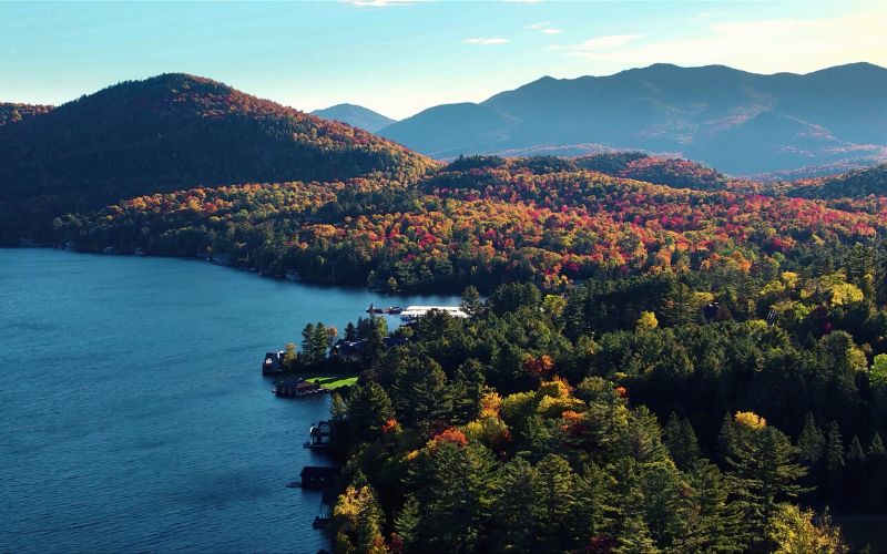
With the Youghiogheny River flowing through and the beautiful Muddy Creek Falls, this state park offers some of the most stunning landscapes in Western Maryland.
Swallow Falls State Park is a must-visit for any hiker! This gorgeous state park is situated only nine miles from Oakland, MD, and about 3.5 hours from Baltimore.
The Swallow Falls Canyon Trail is a family-friendly hike through an old-growth forest to a spectacular waterfall. You’ll walk through tall hemlocks and pass by a few other falls (Tolliver Falls, Upper Swallow Falls, and Lower Swallow Falls) before reaching the towering Muddy Creek Falls. At 53 feet high, it’s the highest free-falling waterfall in the state.
Although rated as an easy hike, you need to watch out for potentially hazardous conditions caused by rain and ice, like slippery rocks and overflowing creeks. Be sure to wear the proper hiking shoes and crampons in winter.
If you’re looking for a longer hike, there’s an option to add a 5.5-mile extension that connects Swallow Falls State Park and Herrington Manor State Park.
2. Billy Goat Trail
- Type: Point-to-Point
- Length: 1.75 miles
- Difficulty: Moderate to Strenuous
Located along the Potomac River, the C&O Canal was once an essential transportation canal for Potomac River communities to float coal, lumber, and agricultural products to sell at the markets. The Chesapeake and Ohio Canal National Historical Park encompasses 184.5 miles filled with historical, natural, and recreational treasures.
The Billy Goat Trail is one of the most visited treks in the larger D.C. area. It’s situated southeast of the Great Falls Tavern Visitor Center in Potomac, MD. This hiking path has three different sections spread across eight miles. Sections A, B, and C each differ in length and difficulty.
Section A is 1.75 miles long and is rated as technical and strenuous. It’s a one-way path downstream to prevent a hiking jam at the Traverse and protect the natural habitat. It begins near Great Falls and ends down at Anglers. The Exit Trail at the halfway point is open to hikers going both ways, so you can choose to do only the top or bottom half if you prefer.
Section C is an easier, 1.6-mile hike with parking available at Carderock. Section B is currently closed due to erosion.
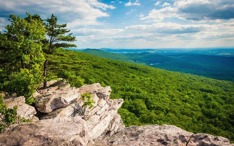
3. Annapolis Rock (Appalachian Trail)
- Type: Out-and-back
- Length: 5 miles
- Difficulty: Moderate
This popular day hike in Maryland’s South Mountain State Park offers you a chance to hike part of the iconic Appalachian Trail.
The 5-mile out-and-back trek along the AT leads to Annapolis Rock. This overlook has breathtaking westward vistas of the 42-acre Greenbrier Lake and Cumberland Valley in Western Maryland.
Parking is at a lot off Route 40, about a quarter mile east of Greenbrier, MD. You’ll need to show up early to grab a parking spot at this busy trailhead, especially on the weekends.
Once at the parking lot, follow the blue-blazed path to the white-blazed Appalachian Trail. Turn right at the sign to hop on the AT and head north to Annapolis Rock. You’ll pass by the highway for a moment before entering the lush forest.
The path then takes you up some steps along the South mountain ridge towards the rocky overlook. Continue north for more incredible views from Black Rock Cliff before heading back to the parking lot.
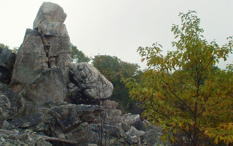
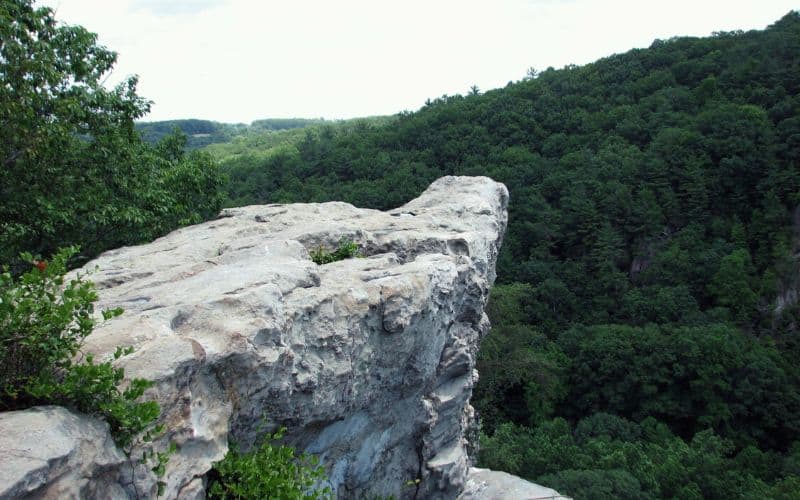
4. Wolf Rock/Chimney Rock Loop Trail, Catoctin Mountain Park
- Type: Loop
- Length: 4 miles
- Difficulty: Strenuous
Catoctin Mountain Park encompasses 5,770 acres of federally protected land in Western Maryland. Catoctin Mountain is part of the Blue Ridge Mountains and the Appalachian mountain range.
The park has 25 miles of hiking trails and nature trails and this loop has the most strenuous sections. The Wolf Rock and Chimney Rock Loop Trail is 4 miles long and features rocky and uneven terrain. The orange-blazed path leads 600 feet up to two lookout points on top of the mountain ridgeline.
The trailhead is at the east corner of the Visitor Center parking lot. From here, the steep and slippery path climbs until it reaches Chimney Rock (1,419 feet) and the Wolf Rock outcropping (1,401 feet). These interesting rock formations provide spectacular views of the surrounding mountains and are the perfect spot to stop for a snack or picnic before returning to your car.
Wear sturdy hiking shoes and watch out for the slippery sections of the route. Some portions of the path may not be well-marked so be sure to download one of the offline trail maps before heading out.
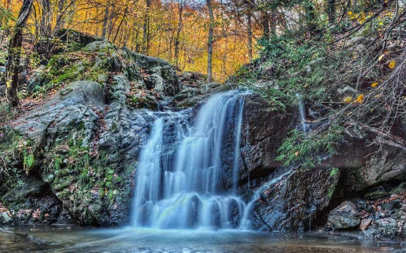
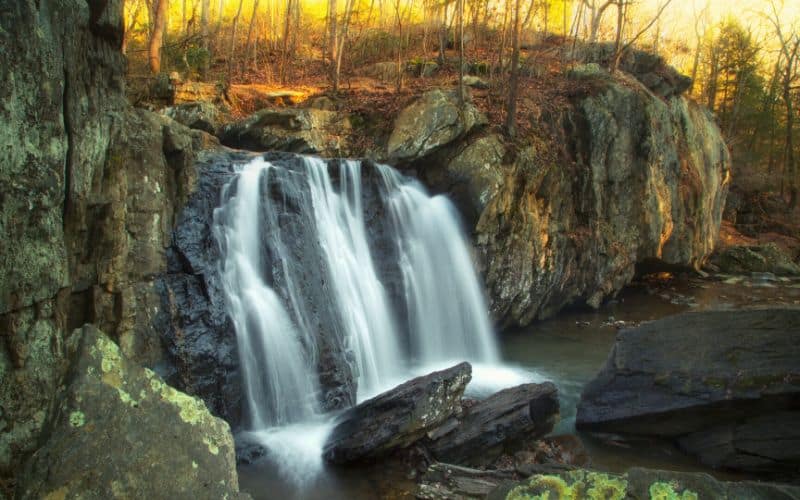
5. Cascade Falls Loop Trail, Patapsco Valley State Park
- Type: Loop
- Length: 2.3 miles
- Difficulty: Easy
Stretching along 32 miles of the Patapsco River, Patapsco Valley State Park covers 16,000 acres and multiple recreational areas with over 200 miles of hiking paths.
The Cascade Falls Trail is found in the Orange Grove Area of the state park. It’s an easy, flat path through the woods that crosses over a few streams. The hike leads to several scenic waterfalls and offers plenty of chances to take a refreshing dip in the water.
The trailhead is located at the Orange Grove Area parking area, where you’ll also find restrooms. This trek can get muddy during the rainy season so come prepared or wait a few days until it dries out.
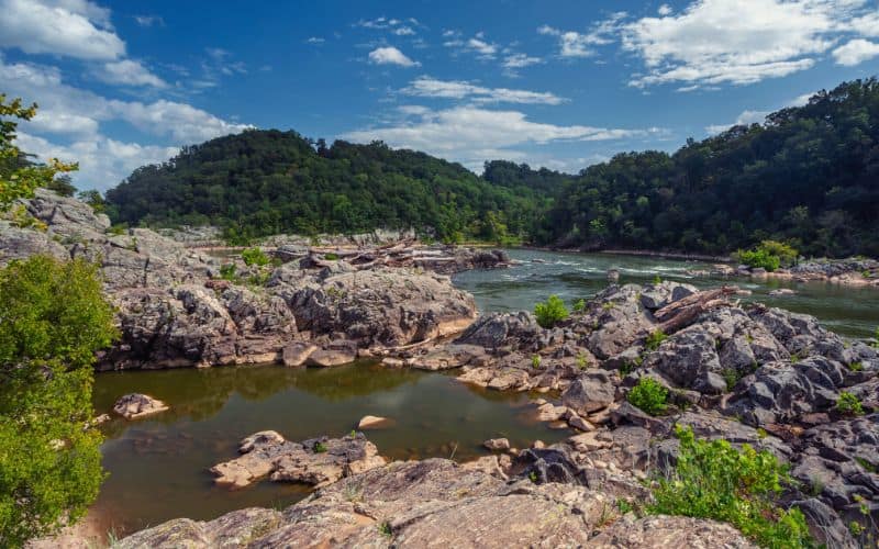
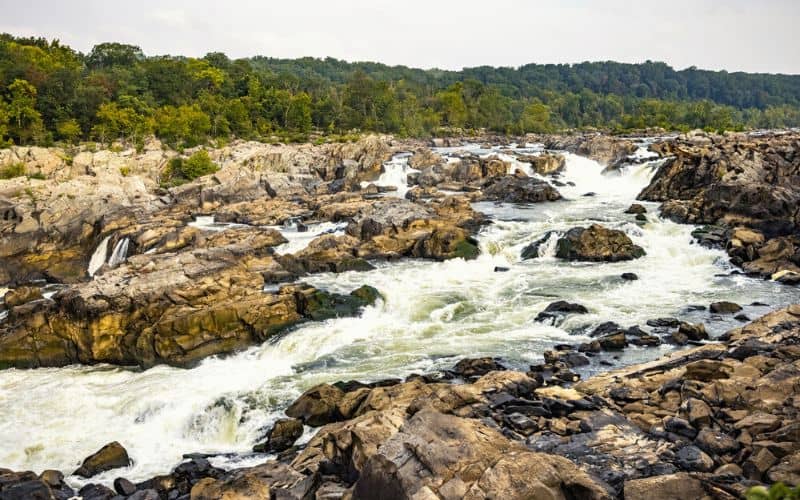
6. Great Falls Overlook Trail
- Type: Loop
- Length: 4.8 miles
- Difficulty: Strenuous
The Great Falls are a series of impressive rapids flowing through the narrow Mather Gorge along the Potomac River. You can peer over the falls from two parks in two states: Great Falls Park on the Virginia side and the C&O Canal National Historical Park on the Maryland side.
This Great Falls Overlook Loop allows hikers to take in breathtaking views of the Great Falls rapids and experience a part of the popular Billy Goat Trail (Section A).
The overlook is located half a mile from the Great Falls Tavern Visitor Center and provides stunning vistas of the rushing rapids as they tumble down the jagged rocks.
Wear sturdy shoes with grippy soles for climbing up boulders and negotiating slippery sections of the rocky trail.
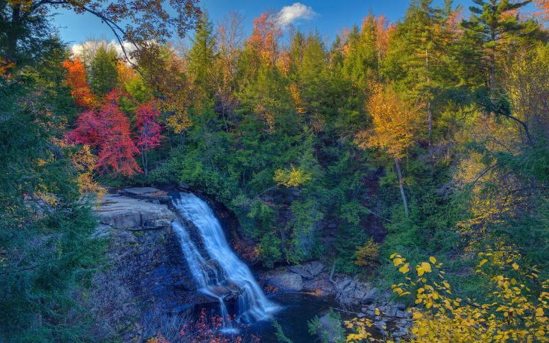
7. Cunningham Falls, Cunningham Falls State Park
- Type: Loop
- Length: 1.1 miles
- Difficulty: Easy
Surrounded by the Catoctin Mountains, Cunningham Falls State Park is an incredibly scenic forested area with miles of hiking paths and a lake where you can cool off after a long trek.
This state park is also home to the highest cascading waterfall in The Free State. The majestic 78-foot-tall Cunningham Falls is located in the William Houck Area of the park.
There are multiple ways to reach the towering waterfall. The shortest and easiest route is via the 0.2-mile wheelchair-friendly Boardwalk to the waterfall observation deck.
The Lower Trail, also known as the Cunningham Falls Nature Trail, is an easy, half-mile hike with interpretive signs and benches along the path that begins close to Hunting Creek Lake.
The Cliff Trail is a ¾ mile trek through difficult terrain with challenging portions along rock outcrops.
For a moderate hike that combines both of the longer routes, take the Cunningham Falls Lower Trail and Cliff Trail Loop.
Swimming in the falls is not allowed, so you’ll need to hike to the lake for a refreshing dip.
8. King and Queen Seat Trail, Rocks State Park
- Type: Loop
- Length: 3.2 miles
- Difficulty: Moderate
Rocks State Park in rural northern Harford County is one of Maryland’s most popular parks. With 855 acres of dense forest growing amongst rocky terrain and boulders, this state park lives up to its name. Kilgore Falls and King and Queen Seat are two of the area’s main attractions, drawing scores of hikers and rock climbers alike.
King and Queen Seat is a unique rock formation resembling a natural throne overlooking the lush woodland. The King and Queen Seat hike is a 3.2-mile loop leading up to gorgeous vistas of Deer Creek and beyond from the rocky outcrop. The path is well-marked with white blazes but can be slippery with wet leaves and muddy during rainy spells.
The trailhead is located at the Rocks State Park parking lot, but you can also access the loop trail from the Rapids Parking Area off Route 24. This hike can get busy, especially on the weekends. It takes most hikers a little over an hour and a half to complete this hike.
9. Sugarloaf Mountain Northern Peaks Trail (Blue Trail)

- Type: Loop
- Length: 7.4 miles
- Difficulty: Moderate
Sugarloaf Mountain has an elevation of 1,282 feet above sea level and its summit is just over 800 feet above the surrounding farmland. The mountain is covered with quartzite rocks and red and white oak trees. Local wildlife here includes whitetail deer, flying squirrels, red foxes, eastern cottontails, great horned owls, and wild turkeys.
The Sugarloaf Mountain Northern Peaks Trail is a popular hiking loop around the summit, called the Blue Trail. It starts at the West View parking lot with a steep uphill, flattens out a bit, and then continues climbing.
Visit in autumn for breathtaking views of the mountain’s fall foliage but be sure to arrive early on the weekends to beat the crowds and secure a parking spot.
10. Torrey C. Brown Rail Trail, Gunpowder Falls State Park
- Type: Point-to-Point
- Length: 19.7 miles
- Difficulty: Easy
Encompassing over 18,000 acres, Gunpowder Falls State Park is one of Maryland’s largest state parks. It was founded in 1959 to preserve the Gunpowder River and the Big and Little Gunpowder Falls. It’s home to a variety of environments ranging from tidal wetlands to steep slopes and more than 120 miles of multi-use trails.
Running along 19.7 miles of the former Northern Central Railway (NCR), the Torrey C. Brown Rail Trail stretches from Ashland, MD on the northern end to the Maryland-Pennsylvania line on the southern end. Along the way, it passes multiple historic communities like Ashland, Phoenix, Monkton, White Hall, Bentley Springs, and Freeland in Central Maryland.
This ADA-accessible path is open to hiking, biking, and horseback riding and makes for an easy stroll that’s perfect for the entire family!
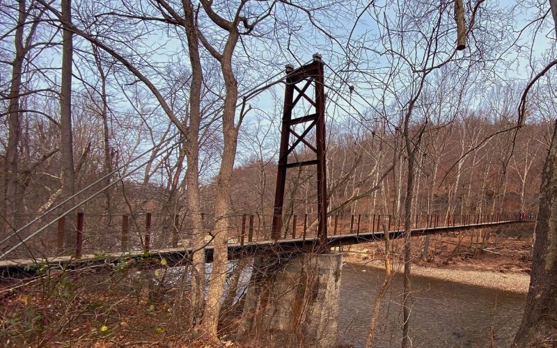
11. Avalon Loop Trail, Patapsco Valley State Park
- Type: Loop
- Length: 21.1 miles
- Difficulty: Moderate
The Avalon Loop winds through several of the recreation areas in Patapsco Valley State Park and most of the Avalon area. This incredible estate park is located only about a 30-minute drive from Baltimore, MD, providing the perfect wilderness escape from the city.
On this forested trek, you’ll come across several waterfalls, creek crossings, and historic ruins, including some old settler houses and an interesting 1930s-era gas pump.
One of the highlights of the hike is the chance to see the Cascade Falls, considered by many as one of the most beautiful waterfalls in the state! Another fun feature is the swinging bridge over railroad tracks that is sure to test your head for heights.
It takes most hikers an average of eight hours to complete this popular loop trail.
12. Long Pond Trail via Deep Run Creek, Green Ridge State Forest
- Type: Out-and-Back
- Length: 9.9 miles
- Difficulty: Strenuous
Covering 49,000 acres, Green Ridge State Forest is Maryland’s largest contiguous area of public land. It’s a working forest in the Ridge and Valley Province of the Appalachian Mountains that shares a 30-mile border with the Potomac River. This state forest has over 80 miles of trails for hikers, mountain bikers, and horseback riders.
The Long Pond Trail via Deep Run Creek is a 9.9-mile hike along Fifteenmile Creek through and over the area’s valleys and ridges. This route is named after the lovely area where Fifteenmile Creek intersects with a rectangular-shaped pond.
Surrounded by lush woodland and water features, you’ll encounter some of Maryland’s most gorgeous landscapes on this challenging yet rewarding hike!
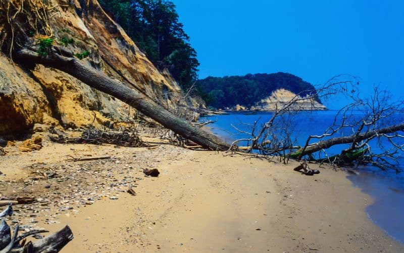
13. Red Trail, Calvert Cliffs State Park
- Type: Out-and-Back
- Length: 4 miles
- Difficulty: Moderate
Calvert Cliffs State Park offers the unique opportunity to walk along Chesapeake Bay’s sandy shores while searching for fossils. Sandy beaches, fossil hunting, and massive cliffs are just a few of the main attractions at this small, yet stunning state park.
There are fossils from more than 600 Miocene-era species scattered amongst the grains of sand on the beach end of the Red Trail. Common finds here include extinct Chesapeake scallops, mollusks, oyster shells, and shark teeth.
The 4-mile-long Red Trail is one of the best hikes Maryland has to offer. It begins at the Calvert Cliffs parking lot and starts off paved, but there are sections with wooden boards, fridges, dirt, gravel, and sand. You’ll pass by a variety of environments from tidal wetlands to dense woodland to towering sandstone cliffs overlooking the bay.
14. Catoctin Mountain Loop
- Type: Loop
- Length: 9.9 miles
- Difficulty: Moderate
Catoctin Mountain Park encompasses 5,770 acres of federally protected land in Western Maryland. Catoctin Mountain is part of the Blue Ridge Mountains, which are themselves part of the Appalachian Mountains. This national park has 25 miles of hiking trails with gorgeous vistas and plenty of wildlife viewing opportunities.
The Catoctin Mountain Loop Trail combines the park’s three main hiking loops. This 9.9-mile route passes by interesting rock formations and overlooks like Hog Rock, Blue Ridge Summit, Thurmont Vista, Wolf Rock, and Chimney Rock. You’ll also get to see the towering 78-foot-tall Cunningham Falls, the highest cascading waterfall in Maryland.
Some parts of the loop are fairly easy, while other sections feature extremely rocky terrain. Some hikers may benefit from bringing trekking poles for use on steep inclines and downhills.
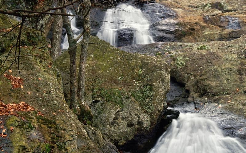
15. Falling Branch Trail to Kilgore Falls
- Type: Out-and-Back
- Length: 0.7 miles
- Difficulty: Easy
Located about five miles north of the Rocks State Park’s main area, the Falling Branch region of the park features a separate 67 acres of protected land.
The Falling Branch Trail to Kilgore Falls traverses pristine wilderness to reach the second-highest vertical-drop waterfall in Maryland. You need to cross the Falling Branch stream to reach the base of the waterfall, so be sure to wear waterproof shoes.
The pool at the base of the falls is the ideal spot to cool off and enjoy a snack before heading back to the trailhead.
Keep in mind that you must make reservations to visit Kilgore Falls and the Falling Branch Area during the weekends and holidays from May 1 to Labor Day. Making a reservation during this time guarantees you a parking spot and allows for a less crowded and more enjoyable hike.
Other Maryland Hiking Trails We Recommend
- Oregon Ridge Nature Center and Park (numerous trails)
- Chesapeake Beach Railway Trail
- Savage River State Forest Trail
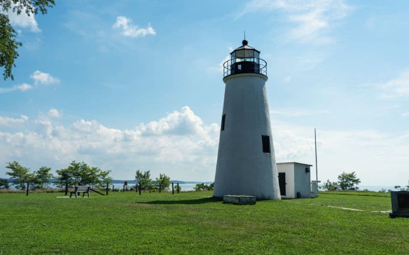
- Turkey Point Lighthouse, Elk Neck State Park
- National Colonial Farm nature trails
- Upper Loch Raven Reservoir Trail
- Thurston Griggs Trail, Hagerstown
Best Hikes in Maryland!
Whether it’s walking on ancient shark teeth fossils along the Chesapeake Bay or scrambling up a rock face to see the rapids at Great Falls, Maryland offers a variety of trails for every type of hiker.
So what are you waiting for? Pack a day pack, lace up your hiking boots, and hit the trails!
What are your favorite Maryland hikes? Please leave us a comment below with your top recommendations! If you enjoyed this article, feel free to share it with your hiking buddies.
