
Over the years, the Swedes have blessed the world with many fine offerings—ABBA, IKEA, meatballs, the Pacemaker, and the Nobel Prize are just a few. But for our money, one of the best things to ever come out of Konungariket Sverige is a sport that’s only beginning to find its footing in North America: orienteering.
In this article, we aim to give you the low-down on this wonderfully fun sport with a short and sweet beginner’s guide to orienteering basics.
Table of Contents
What Is Orienteering?
Orienteering is a type of trail-running, navigation, obstacle-course, and geocaching hybrid.
During a race, participants are timed while attempting to complete a course or route through (normally) backcountry terrain with the use of only a map and compass.
Throughout the course, participants navigate toward a series of checkpoints (“controls”). At each checkpoint, the orienteer decides the best route to run or walk to the next one until reaching the finish point.
Orienteering events have courses of differing lengths and difficulty. These range from short, easy courses in areas with more notable (and possibly man-made) features to marathon-length, expert-level epics in more remote areas.
First developed in the 19th century to test the navigational competence of the Swedish military, these days orienteering is a worldwide affair. It not only has its own international governing body, but also hundreds of thousands of meet participants who compete at local, regional, and national levels.
In recent years, orienteering has branched out to include not only standard, daytime, on-foot orienteering (“Foot-O”), but also kayaking, horse-riding, urban, nighttime, and mountain biking versions.
Why Learn Orienteering?
Let’s start with the bottom line: orienteering is fun!
First up is the social aspect. At a typical meet, you’ll join dozens, hundreds, or maybe even thousands of others. Many of these will be diehard orienteers, some are hikers, trail runners, map geeks, or none-of-the-above just looking to try their hand at something new.
The activity itself is one that combines the excitement of a race with the thrill of a treasure hunt and the more cerebral challenge of negotiating your way through varying types of obstacle-ridden terrain.
Not yet sold? Well, the fact that most meets culminate with a large-scale dinner and drinks party during the awards ceremony might just do the trick…!
If fun isn’t your thing, there are plenty of other reasons why taking up orienteering is a good idea for the outdoor adventurer.
Whether you consider yourself primarily a hiker, backpacker, trail runner, or navigation geek, orienteering adds another element to your regular schtick. Not only can that added element help to spice up a tired routine, but it can also, most importantly, seriously improve your navigation skills.
Because GPS devices are forbidden at meets, participants are forced to rely on their map and compass skills alone—all whilst embroiled in a race against the clock. As such, upgrading your ability to navigate quickly and accurately is all but inevitable if you make “O” meets a regular thing.
Orienteering Clubs and Organizations
So, just how is a would-be orienteer to get involved?
Below, we’ve listed a handful of clubs and organizations to help you get started:
- Orienteering USA: The national organization’s website includes a state-by-state list of clubs and plenty of articles to help newbies learn the ropes.
- Empire Orienteering Club: A club organizing meets in the New York area.
- Quantico Orienteering Club: A Virginia-based club that organizes meets and more serious races in the Mid-Atlantic region.
- The Scouts: For the youngsters…
Gear and Clothing
When heading to your first meet, we recommend you bring and wear the following:
- Outdoor footwear: hiking boots, trail shoes, or trail runners, depending on the terrain and how fast you plan on going
- Outdoor clothing: the usual layering system adapted to suit weather conditions
- A light backpack (normally only necessary on longer courses in backcountry terrain)
- A simple compass
- A safety whistle (in case you need to summon help)
At any event, a map of the course terrain will be provided. On longer courses, we recommend treating your race as you would a long day hike, carrying a larger pack with each of the Ten Essentials of Hiking.
Your First Meet
To give you an idea of how the day of your first meet will go down, we’ve made a shortlist of an event’s main elements, from registration through to course completion:
Registration
At the registration desk, you’ll be asked to sign a waiver, pay a fee, and choose your course.
At the Starting Line
After registering, make your way to the start point for your chosen course. Start times are usually staggered. In many cases, you’ll be handed your map now rather than at the registration desk.
The Course Map
Orienteering maps are crammed with much more detail than your standard topo map and include many symbols (see below) unique to orienteering.
Because these maps are aligned to magnetic north instead of true north, you won’t have to adjust your compass or compass readings for magnetic declination.
Controls
Back in the day, orienteers would record their visit to each “control”—control points on the map to which you must navigate—using a simple paper punch. Nowadays, most events use an electronic “e-punch” that records your visit when you insert an electronic timing stick.
Your map will provide descriptions of the topographical feature on which each control can be found.
In most cases, you’ll have to visit controls in numerical order, but some events let you vary the order, often leaving it up to you with a view to test your course management.
How you navigate between each control on any course is entirely up to you.
Courses for beginners usually take place in terrain where there are waymarked trails and notable features. At the intermediate level and upwards you’re more likely to be in remote, less-featured landscapes that require precise and careful navigation around obstacles such as lakes, rivers, outcrops, cliffs, or dense forests.
The Finishing Line
When you complete your course, you’ll hand in your control card or e-punch at the registration desk. In the case of the latter, at some events, you will be able to print out an analysis of your performance between each control point and your overall time.
Basic Orienteering Skills to Learn
Using a Topographic Map
A topographic map shows not only the features you would expect to encounter such as roads, trails, or lakes but also shows the topography of the area by using contour lines. At a very basic level, the closer together the distance between these lines, the steeper the slope will be. If the distance is very wide apart, then that area is relatively flat.
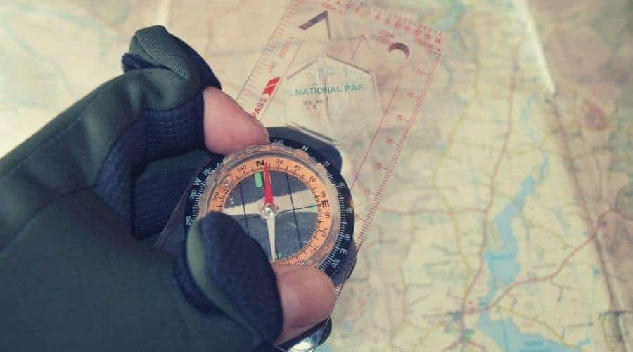
Using a Compass
Most common compasses will consist of a magnetic needle set into the compass housing with the red end of the compass needle pointing towards magnetic north.
Other useful components of a compass are:
- Orienting arrow
- Direction of travel arrow
- Orienting Lines
You will use your compass to take bearings (determine the direction of an object relative to yourself) to help determine either your location or the direction you want to travel in.
Further reading: If you are completely new to the sport, then you’ll need some gear. Head on over to our reviews for the Best Orienteering Compass.
Using them together
Combining the two tools together allows you to easily determine (1) your current location, (2) the next location you want to get to, and then calculate the direction, distance, and time it should take you to get there.
The first can be done either by “mental mapping”, i.e. knowing where you are by observing your surroundings or by using your compass and map to triangulate your position. Once you have worked this out, simply take a bearing from your current position on the map to your next waypoint with your compass, and head off in that direction.
3 Tips for Newbie Orienteers
1. Orienteering symbols can appear like hieroglyphics to the uninducted. Before heading to your first meet, take some time to familiarize yourself with the most common orienteering map symbols so you know what they mean when navigating out in the field. A good place to start your research is this resource from Maprunner.
2. While the objective of orienteering is to complete the course in as little time as possible, don’t rush, make sure you take accurate compass readings and assess your route choice carefully. Taking a few extra seconds or minutes to do good navigational work and route selection could save you a lot of time over the course of the day.
3. Trying to travel on a compass bearing can be a difficult task, particularly when attempting to move quickly through the terrain. To spare yourself having to keep one eye on your compass while avoiding rocks, scrub, bushes, and so on, try to pick an easily distinguishable feature in the distance to aim for, navigate to that, and then repeat the process until you reach the next control.
