While famous for its excellent southern hospitality and delicious peaches, the state of Georgia also boasts incredible natural beauty.
From the towering peaks of the Appalachian Mountains to Providence Canyon’s deep gorges, Georgia is a nature lover’s dream destination. Best known as the location of the Appalachian Trail’s southern terminus, the Peach State offers thousands of miles of scenic hiking trails to explore.
Whether you’re trekking to the 730-foot-high Amicalola Falls or taking in the breathtaking views from Brasstown Bald’s 4,784 feet summit, Georgia’s hiking trails have something for everyone, from beginner hikers to seasoned veterans.
In this guide to the best hiking the Peach State has to offer, we’re covering everything you need to know about Georgia’s top trails. This includes each hike’s unique features, difficulty level, and length, as well as parking info and tips on when to visit.
So what are you waiting for? Grab your hiking boots and let’s hit those trails!
Table of Contents
- 1. Amicalola Falls, North Georgia
- 2. Brasstown Bald, Chattahoochee National Forest
- 3. Long Creek Falls
- 4. Indian Seats Trail, Sawnee Mountain Preserve
- 5. Panther Creek Falls
- 6. West Rim Trail to Cherokee Falls, Cloudland Canyon State Park
- 7. Canyon Loop Trail, Providence Canyon State Park
- 8. Yonah Mountain Trail
- 9. Springer Mountain via Appalachian Trail
- 10. Blood Mountain via Appalachian Trail/Byron Reece Trail
- 11. Tennessee Rock Trail, Blackrock Mountain State Park
- Other Georgia Hikes We Recommend
- Happy Hiking!
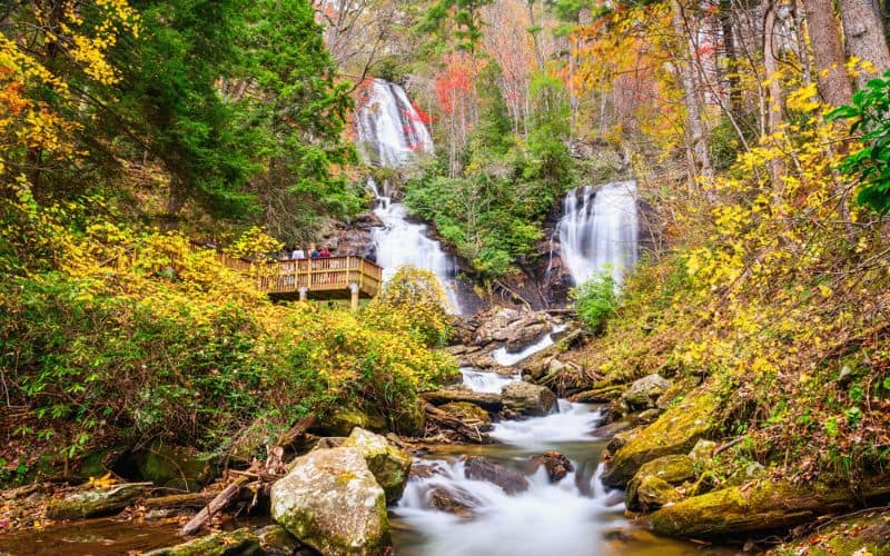
1. Amicalola Falls, North Georgia
- Type: Loop
- Length: 2.1 miles
- Difficulty: Moderate
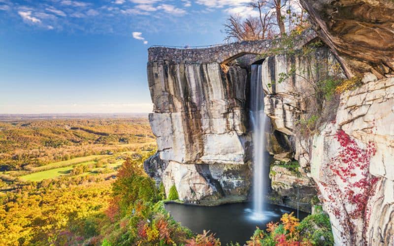
Amicalola Falls State Park covers 829 acres on the cusp of the North Georgia Mountains in Chattahoochee National Forest. This small yet mighty state park’s claim to fame is Amicalola Falls, a massive 730-foot waterfall. This waterfall is known for being not only the tallest in the state but also the third-highest cascading waterfall east of the Mississippi River.
The fall’s name comes from the Cherokee language word for “tumbling waters”. A term that accurately describes the water flowing over multiple tiers of cascades as it tumbles down the rocky slope flanked by trees.
The Amicalola Falls loop is a 2.1-mile hike to the top of this majestic waterfall. The path starts at the Amicalola Falls State Park visitor center. Along the trail, you’ll pass under a stone archway entrance to the Appalachian Trail Approach trail. It’s only 10 miles from this arch to the southern terminus of the AT on Springer Mountain.
After this, you’ll trek up switchbacks through a hardwood forest and continue to the East Ridge Trail, which offers incredible vistas of the mountains. Be prepared for the 425 steps to the top of the falls!
2. Brasstown Bald, Chattahoochee National Forest
- Type: Out-and-Back
- Length: 1.4 miles
- Difficulty: Moderate
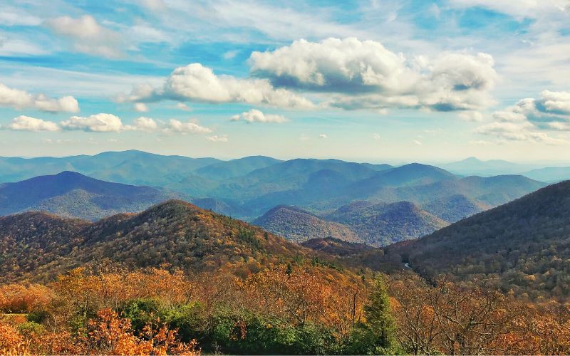
The Peach State is home to two national forests: Chattahoochee National Forest and Oconee National Forest. The Chattahoochee-Oconee National Forest encompasses almost 867,000 acres of incredible natural beauty to explore, including thousands of miles of rivers and about 850 miles of trails.
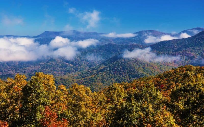
Chattahoochee-Oconee is also home to the highest elevation point and tallest mountains in the Peach State. At 4,784 feet above sea level, Brasstown Bald is the place to go for the best views of Georgia’s stunning landscapes. It’s also a popular spot to visit in the autumn for breathtaking vistas of fall foliage that seem to go on forever.
Brasstown Bald Visitor Center features picnic tables with scenic views, a natural science and history museum, a general store, and three trailheads by the parking area. The visitor center’s observation deck offers 360-degree views of the region and three neighboring states.
The Brasstown Bald Summit Trail is a short but very steep hike from the visitor center’s parking lot to the viewing platform. It’s 1.4 miles out and back along a paved path to the top of the Bald.
3. Long Creek Falls
- Type: Out-and-Back
- Length: 2 miles
- Difficulty: Easy
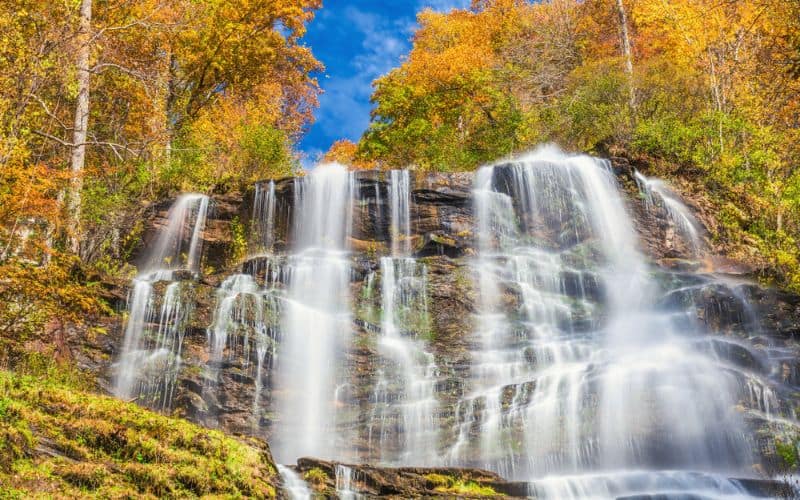
Long Creek Falls are the most visited waterfalls in Fannin County. This is considered one of the best hikes in the Peach State in part because you get to walk along a portion of the iconic AT on your way to the waterfalls.
It’s an easy, 2-mile round-trip hike through Three Forks valley to reach Long Creek Falls. Three hiking trails converge in this valley near Blue Ridge, GA: the Appalachian, the Benton MacKaye, and the Duncan Ridge trails.
On your leisurely hike to the falls, you’ll explore one of the most stunning portions of the AT in the Peach State. The AT’s southern end is located at Springer Mountain, just four miles from here.
To get to the trailhead and parking area at Three Forks, take the bumpy dirt road that parallels Noontootla Creek. The hiking path climbs gently as it follows Long Creek toward the falls. You’ll encounter three steep sections before arriving at the blue-blazed spur trail to the falls a little over 1 mile from the trailhead.
The spectacular Long Creek Falls measure a total of approximately 50 feet and are separated into two sections of cascading water. The cascades are shaded by a canopy of hemlock and surrounded by rhododendron and tulip poplar.
4. Indian Seats Trail, Sawnee Mountain Preserve
- Type: Loop
- Length: 3.2 miles
- Difficulty: Moderate
Sawnee Mountain Preserve is the perfect wilderness escape from the hustle and bustle of Atlanta. It’s located in Cumming, about 40 miles north of the capital city. It features an 821-acre natural area with 11 miles of hiking trails to explore, picnic tables for enjoying an outdoor lunch, and an interactive visitor center where you can learn about the area.
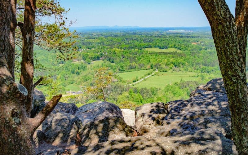
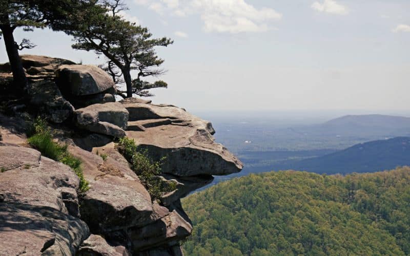
The preserve covers a portion of the Blue Ridge Mountain Range, including Sawnee Mountain. One of the area’s most popular attractions is an interesting rock formation named Indian Seats. The rocks are perched at the very top of the trails and offer unbelievable views of the North Georgia Mountains.
Indian Seats Trail is a well-marked, 3.2-mile, moderate hike to the peak of Sawnee Mountain. It’s both beautiful and good for beginners. It’s easy to get to, shaded by a forest canopy, well-maintained, and has plenty of parking.
The route begins at the parking area, winds through the trees, up switchbacks, and passes by the entrance to abandoned gold mines. Once you reach the rocky summit, you’re instantly rewarded with some of the best views in the state.
This is one of our favorite hikes near Atlanta.
5. Panther Creek Falls
- Type: Out-and-Back
- Length: 6.9 miles
- Difficulty: Hard
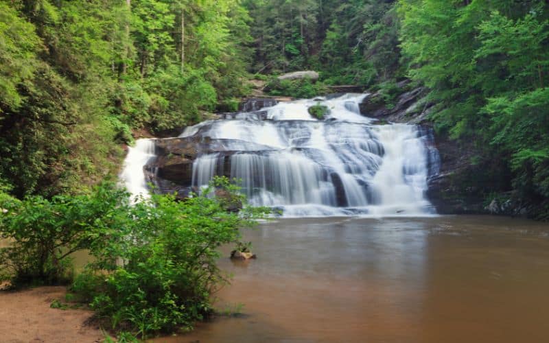
Yet another natural wonder located in Chattahoochee National Forest, Panther Creek Falls in Habersham County is one of the Peach State’s most beautiful waterfalls. It’s also on one of the region’s best backpacking routes.
Panther Creek Falls is a chain of cascading waterfalls tucked amongst a scenic landscape of towering trees and moss-covered rocks. The water flows over several tiers of boulders as it tumbles down into a pool below. The bottom of the cascades has a pool and sandy beach that’s perfect for taking a refreshing dip after a long hike.
The hike to Panther Creek Falls is a strenuous trail beginning at the Panther Creek Recreation Area’s picnic tables. It starts along Panther Creek and traverses a hardwood forest covered in green moss before climbing steeply into a more vertical terrain through rocky outcrops.
Unfortunately, this trail was heavily damaged by Hurricane Zeta and is currently open only to intermediate and advanced hikers. Many of the wooden bridges were taken out and hikers must be prepared to ford Panther Creek and smaller tributaries to reach the falls. Contact the Ranger District for current conditions before attempting this hike.
6. West Rim Trail to Cherokee Falls, Cloudland Canyon State Park
- Type: Loop
- Length: 4.8 miles
- Difficulty: Moderate to Hard
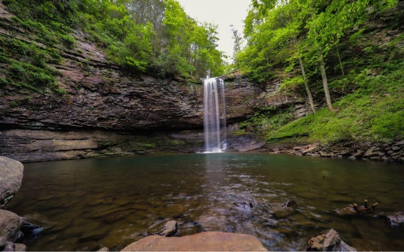
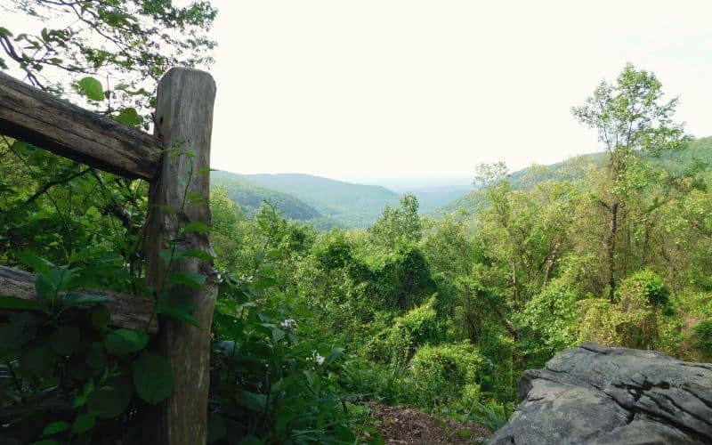
Featuring canyons, waterfalls, caves, sandstone cliffs, forests, and wildlife galore, Cloudland Canyon State Park is a must-visit.
This 3,538-acre recreation area on Lookout Mountain’s western border is one of Georgia’s largest and most beautiful state parks. It’s home to 64 miles of hiking trails, a fishing pond, picnic areas, cabins, and several scenic overlooks, all of which make it one of our favorite places to go camping in Georgia, too.
West Rim Trail to Cherokee Falls, also known as the West Rim Loop Trail, was once rated as one of the top 10 hikes in the United States by Backpacker Magazine. It’s a moderately strenuous hike with epic views from the upper canyon to the stunning 60-foot-high Cherokee Falls.
The hike starts at the East Rim Trailhead and follows the Waterfall Trail before continuing on to the West Rim Trail, which descends to the canyon floor.
7. Canyon Loop Trail, Providence Canyon State Park
- Type: Loop
- Length: 2.5 miles
- Difficulty: Easy to Moderate
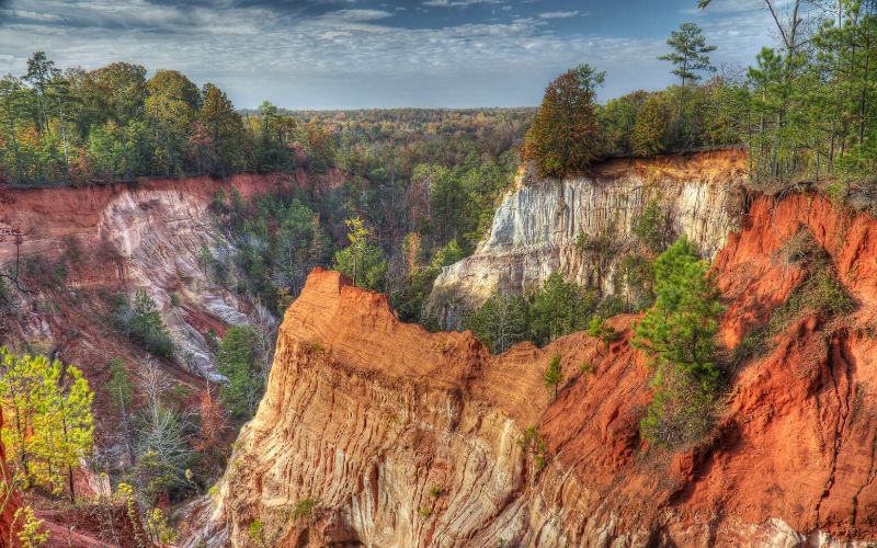
Providence Canyon State Park offers a truly unique landscape. Vibrant, red-toned canyon walls contrast with and complement a green backdrop of maple and oak trees to provide sumptuous views everywhere you look.
This gorgeous 1,003-acre state park is situated in the southwest part of the Peach State. The main attraction here is the incredible Providence Canyon, which is commonly called the “Little Grand Canyon” and is one of the Seven Natural Wonders of Georgia.
The Canyon Loop Trail is a scenic circuit around nine of the park’s spectacular gorges. The path begins at the visitor center and descends into the base of the canyon. Along the way, hikers are treated to an up-close look at the multi-colored soil levels on the walls. The soil here is incredibly fragile, so stay away from the canyon walls and towards the center of the path.
8. Yonah Mountain Trail
- Type: Out-and-Back
- Length: 4.4 miles
- Difficulty: Hard
Hiking to the top of Mount Yonah offers peerless vistas of the surrounding area. This challenging, yet incredibly scenic hike is considered to be one of the best North Georgia hiking trails. Mount Yonah is located along the Appalachian Mountains’ foothills, just a 10-minute drive north of Cleveland, GA.
Yonah Mountain Trail, also known as the Mount Yonah Trail, is a strenuous hike with almost 1,500 feet of elevation gain. This path meanders through the forest and wildflowers as it climbs the mountain to reach the mind-blowing views at its rocky summit.
Along the way, you’ll encounter steep drop-offs, a few boulder scrambles, and an intense uphill section. This makes it best suited for more experienced hikers. The Mount Yonah Trailhead is found on Forest Service Road 323 on the west side of the mountain.
9. Springer Mountain via Appalachian Trail
- Type: Out-and-Back
- Length: 8.5 miles
- Difficulty: Moderate
Located at the divide between the north and south sections of the Blue Ridge Mountain Range, Springer Mountain is famous for being the site of the Appalachian Trail’s southern terminus. The AT begins (or ends) on the northeast side of the mountain and its peak features a plaque with the AT sign.
The summit of Springer Mountain can be reached from several different trailheads, and some of these trails combine with the AT for a few miles.
The Springer Mountain via the AT hike begins at Amicalola Falls State Park. Look for the blue-blazed hiking path behind the visitor center. The path takes you up a few steep inclines on the way to the summit, so be prepared for a good workout!
Another popular way to reach Springer is to take the trail off Forest Service Road 42. From here, it’s a 0.9-mile trek south until you reach the top.
10. Blood Mountain via Appalachian Trail/Byron Reece Trail
- Type: Out-and-Back
- Length: 4.4 miles
- Difficulty: Hard
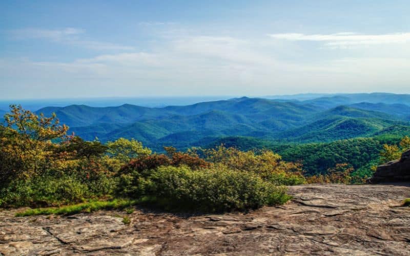
For a route along the AT with absolutely breathtaking views, check out this 4-mile hike to the rocky peak of Blood Mountain.
This route takes you along the Byron Reece Trail and the AT up to gorgeous vistas from the highest elevation summit along the Georgia segment of the AT. It offers non-stop views as it winds through a lush valley before climbing up to the mountain’s summit. This is a popular hike in the fall when the hardwoods come alive with beautiful red and orange colored leaves.
This trek begins at the Byron Reece Trailhead located in the Byron Herbert Reece Memorial parking lot and picnic area near Neels Gap. From here, the blue-blazed path crawls uphill to a three-way intersection. Follow the Appalachian National Scenic Trail for 1.5 miles to reach the top of Blood Mountain.
11. Tennessee Rock Trail, Blackrock Mountain State Park
- Type: Loop
- Length: 2.2 miles
- Difficulty: Moderate
Nestled amongst the rolling Blue Ridge Mountains, Blackrock Mountain State Park is the highest-elevation state park in the Peach State. It’s home to four hiking paths leading to spectacular views of the area’s streams, waterfalls, wildflowers, and woodlands.
The Tennessee Rock Trail is the most popular in the park. It’s a 2.2-mile circuit over Black Rock Mountain’s 3,640-foot-high summit with jaw-dropping views towards the northwest. On a clear day, you can see three neighboring states: North Carolina, South Carolina, and Tennessee.
The Tennessee Rock Trailhead is located by the park’s main parking area. From here, the well-marked trail winds its way up the mountainside until it reaches its peak. After the peak, the path takes you to the Tennessee Rock Overlook. Take a moment here to look all the way over to the state of Tennessee before heading back down to the visitor center.
Other Georgia Hikes We Recommend
- Smith Creek Trail, Unicoi State Park
- Hurricane Falls Trail, Tallulah Gorge State Park
- Coosa Backcountry Trail, Vogel State Park
- Raven Cliff Falls, Raven Cliff Wilderness
- Woody Gap to Big Cedar Mountain and Jarrard Gap
Happy Hiking!
From the red-striped walls of the “Little Grand Canyon” and Blood Mountain’s rocky mountain summits to the towering Amicalola Falls, the Peach State offers some of the most spectacular natural landscapes in the country.
No matter if you’re a beginner or a seasoned hiker, you’re bound to find the perfect Georgia hiking trail for you on this list.
What are your favorite Georgia hikes? Let us know in the comments below! And if you enjoyed this article, feel free to share it with your hiking buddies!
