
Are you craving stunning sunrises, exhilarating cliffside walks, and scenic strolls on the beach? Why not enjoy all of them in one park? With over 120 miles of hiking trails, Acadia National Park has something for everyone.
There are shorter hikes with challenging ascents, easy-going family-friendly strolls, and even iron rung-laden adventures to be had in this intriguing national park off the coast of Maine. Read our guide to find the best options for you and your hiking party and to get top tips to prepare for your outing.

Table of Contents
What Are The Top Hikes In Acadia National Park?
Our favorite hikes in Acadia NP are given in the list below.
- Precipice Trail
- Beehive Trail
- Jordan Pond Path
- Cadillac Mountain South Ridge Trail
- Cadillac Mountain Summit Loop Trail
- Acadia Mountain Trail
- Ocean Path
- Bowl Trail

1. Precipice Trail
The 2.51-mile Precipice Trail loop features heavy use of iron rungs and ladders, taking roughly 2 to 3 hours to complete. With just over 1,200 feet of ascent and significant exposure, this is a strenuous hike with a high degree of difficulty. But don’t let the stats deter you. This is one of the most memorable hikes in Acadia and top of our list for a reason.
Going up the iron rungs and ladders is much safer than down-climbing them. For that reason, we also recommend this hike be done as a loop rather than an out-and-back, especially if you have a fear of heights.
Traveling steadily up the east face of Champlain Mountain, with the use of iron rungs and ladders, this trail brings you into contact with the raw power of the oldest national park east of the Mississippi. Some sections of the trail are just a few feet wide, with the rock face on one side and a precipitous drop on the other, so a good head for heights and composure are a must.
The first 0.3 miles from the lot brings a steady 300 feet of elevation gain with a slight dip before coming to a fork. Take the left for the steep route upwards. If you are feeling at your limit, it may be better to go right or turn around. If you are up for a bit of a thrill and happy to be crawling beneath boulders and clambering over rock on exposed sections of trail, take the left.
The following half mile brings with it 700 feet of ascent. A tall order, granted, but one that will reward you with sweeping views of the coastline and an altogether thrilling ride on the way to the top. Once you have summited, take the Champlain North Ridge Trail and follow the Orange and Black Path to get back to your car.
Due to returning and endangered peregrine falcons nesting in the area, this trail is usually closed late spring to mid-August. As such, it’s wise to check for updates from the National Park Service before setting off to do this hike. Winter conditions on this trail can also be treacherous, so the best time to go is from mid-August to mid-fall.
The parking area for the trail is north of the Schooner Head entrance fee station on the Loop Road. As one of the more popular hikes, parking fills up fast. Spots are limited and you are not allowed to park outside of designated sites. The early bird gets the worm! Get there no later than 8 am at the latest to avoid disappointment.

2. Beehive Trail
The Beehive Trail is a strenuous 1.38-mile loop with 571 feet of ascent, taking 1 to 2 hours to complete. This outing is best suited for fit adults and involves the use of iron rungs, making it unsuitable for those uncomfortable with heights.
Start from the Sand Beach parking area and hustle onto the Bowl Trail. You’ll gain elevation quickly from the beginning. Take the right turn onto the Beehive Trail 0.15 miles into the trail. From here, you’ll begin to climb in earnest and arrive at the Beehive (518) summit after just .2 miles.
When descending, you can take a shortcut by taking a left onto the Bowl Trail 0.2 miles after the summit. This, however, will take you away from The Bowl, a beautiful lake that is snuggled away in the mountains a short distance further along the Beehive.
Once you reach the bowl, allow the sight of this idyllic little spot to soak in for a while and then take the left to continue your descent on the loop. Once past Halfway Mountain on the return, do not take a right onto the Gorham Mountain Trail, but continue on the Bowl Path to get back to the parking lot.
Like the other parking lots, this one gets full quickly, so get there before 8 or 9 am.

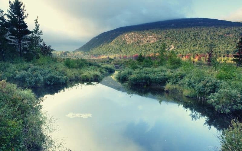
3. Jordan Pond Path
The Jordan Pond Path is a pleasant, family-friendly 3.3-mile loop with gentle ups and downs. This trail takes around 1.5 to 2 hours to complete, and the walk can easily be turned into an out-and-back if you run out of steam.
The trail skirts around the edge of Jordan Pond, a quaint little body of water that teems with salmon and trout and is exceptionally clear, allowing you to peer down to depths of 46 feet.
This hike is also easily combined with South Bubble Mountain. If you choose to hike the South Bubble Trail, you’ll be able to take in Bubble Rock, a giant boulder resting precariously on a slope at the summit.
Park in the Jordan Pond lots, not at Jordan Pond House.
Your route will weave in and out of carriage roads financed by John D. Rockefeller, Jr. Much of the original road is still in the park today! Bikers and skiers use these roads throughout the year.
At the end of your hike (or beginning, if you prefer your dessert first) “pop” into the Jordan Pond House (open daily from late May to late October) to enjoy their famous popovers!
4. Cadillac Mountain South Ridge Trail
The Cadillac Mountain South Ridge Trail is a 4-mile, point-to-point hike with the difficulty level depending on your starting point. Begin from the summit, you’re in for a pleasant downhill walk to the Blackwoods Campground. If you set out at sea level, this is a challenging hike with a gradual but sustained ascent of 1,400 feet.
A highlight of either option is passing by The Featherbed, a hidden gem of a lake nestled in between the highly popular viewing point of Cadillac Mountain and Dyke Peak and Eagle’s Crag.
Either way, the logistics are a bit tricky. You can get to Blackwoods Campground by riding the free Island Explorer shuttle bus. Once you summit Cadillac Mountain, you can arrange to be picked up or continue down on the Cadillac Mountain North Ridge Trail, where a bus stop awaits.
Always be sure to check that the bus is running, as weather conditions can cause temporary road closures or a suspension of service.
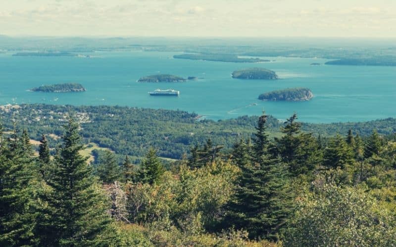
5. Cadillac Mountain Summit Loop Trail
Beginning and ending near the top of Cadillac Mountain, the 0.3-mile Summit Loop Trail rewards minimal physical effort with incredible vistas, boasting spectacular views of Bar Harbor, Dorr Mountain, and the many small islands that pepper the ocean’s surface.
Cadillac Mountain is the tallest point on the Atlantic coastline. It is also one of the first spots in the United States to feel the sun’s embrace every morning, making it the ideal spot for sunrise photo ops. The Native Americans that lived in Acadia, in fact, were called the Wabanaki, or the “People of the Dawnland.”

6. Acadia Mountain Trail
The Acadia Mountain Trail is a vigorous 2.5-mile loop with an impressive 700 feet of ascent in under 1 mile, making it harder and more strenuous than other short hikes on our list.
The reward for your efforts are commanding views of Somes Sound to the east and Beech Mountain to the southwest. This trail has a little less traffic than others on Mount Desert Island, so there’s a far better chance of having the summit all to yourself, too.
The trailhead and lot are located along Route 102, across from Echo Lake. Cross the road to find the standard trailhead marker and begin on the St. Sauveur Trail, then take the left heading toward Acadia Mountain at the next fork.
Descend using the Man O’War Brook Fire Road by taking a left after the overlook. On the way down, you’ll pass a gorgeous little waterfall and enjoy further outstanding views of the sound.

7. Ocean Path
The Ocean Path Trail is an easy out-and-back hike that covers a 3.8-mile round trip from Sand Beach past Thunder Hole to Otter Point and back. Starting from the upper parking lot at Sand Beach, this hike runs parallel to the Park Loop Road. While popular and often busy, it provides a great way to see the park’s best features without encountering any steep ascents.
This is one of the most popular Acadia National Park hikes, especially around noon every day, so it’s not the best option for lovers of solitude. That said, there are plenty of features that make the Ocean Path well worth doing.
About 2.5 miles into the walk, you’ll encounter the Otter Cliff. With cliffs reaching 110 feet high, this is the highest headland north of Rio De Janeiro and a true sight to behold!
Next up is Thunder Hole, a natural feature on the rocky shoreline that takes its name from the thunder-like sound it emits when large waves crash into the shore, sending sprays of water up to 40 feet high.
Finally, at Sand Beach, you’ll find the perfect spot for a post- or mid-hike dip. A lifeguard is on duty at the beach in the summer, so you don’t have to worry too much about those thunderous waves!

8. Bowl Trail
At 1.4 miles and with 420 feet of ascent, the Bowl Trail is a moderate out-and-back hike that allows you to enjoy the picturesque Bowl Lake while avoiding the more challenging aspects of The Beehive Trail. It takes 1 to 2 hours to complete but does include some steep gradients, making it less suitable for younger kids.
The lake showcases a wealth of different features, from ponds to forests and granite ledges. The hike is pleasant and not too challenging and the trail gives you a small but satisfying taste of everything Acadia National Park has to offer.
Autumn visits are especially recommended. Then, the orange, red, and brown foliage is worth the price of admission alone! Peak foliage usually occurs in mid-October, depending on the year.
The trail starts at the same lot as The Beehive Trail, around 100 feet north of the Sand Beach parking area.
Want Further Tips for Acadia National Park Hiking?
Our top tips to get the most out of your chosen Acadia trail are listed below.
- There is a fee to enter the park: $30 per vehicle; $25 per motorcycle; and $15 per person if you enter on foot, horse, or bike. An annual pass for Acadia National Park specifically is available for $55.
- The park is dog-friendly, but pets need to be leashed at all times.
- Most visitor centers are closed in winter
- There is limited cell service and no public wifi
Ready To Hit The Acadia National Park Trails?
With the diverse range of hikes in Acadia, this unique national park is a must for any hiker eager to explore the world’s most unique and exhilarating hiking destinations. We hope our list and tips help in finding the best hikes in the park for you and your hiking companions!
Did you enjoy our roundup of the best hiking trails in Acadia National Park? Tell us what you think in the comments! We’d love to hear from you!