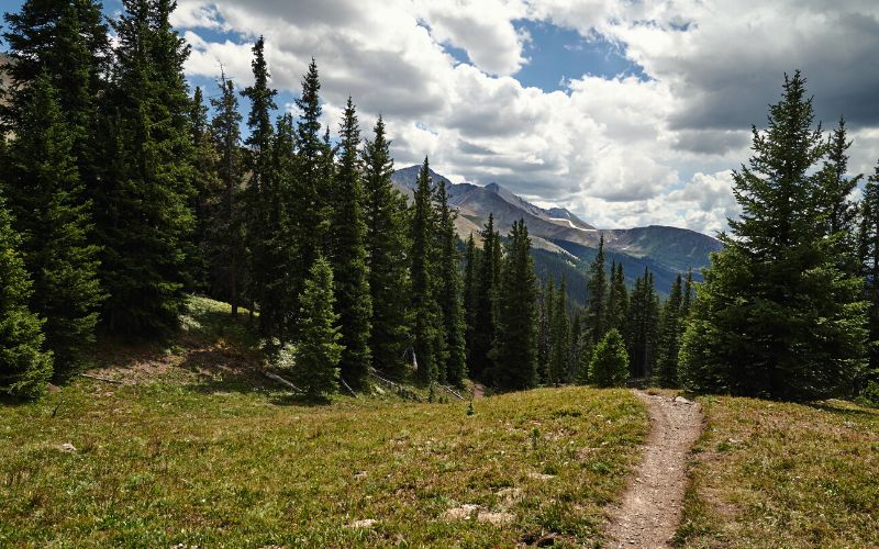
It’s impossible to talk about Colorado without mentioning world-class hiking. The Centennial State is known for its impressive peaks, awe-inspiring scenery, and wild rock formations. The best part is you don’t have to be an experienced hiker to take advantage of all this state has to offer.
Use this guide to find your perfect trail. We’ve included something for everyone, from relaxing waterfall hikes to demanding 14,000-foot scrambles.
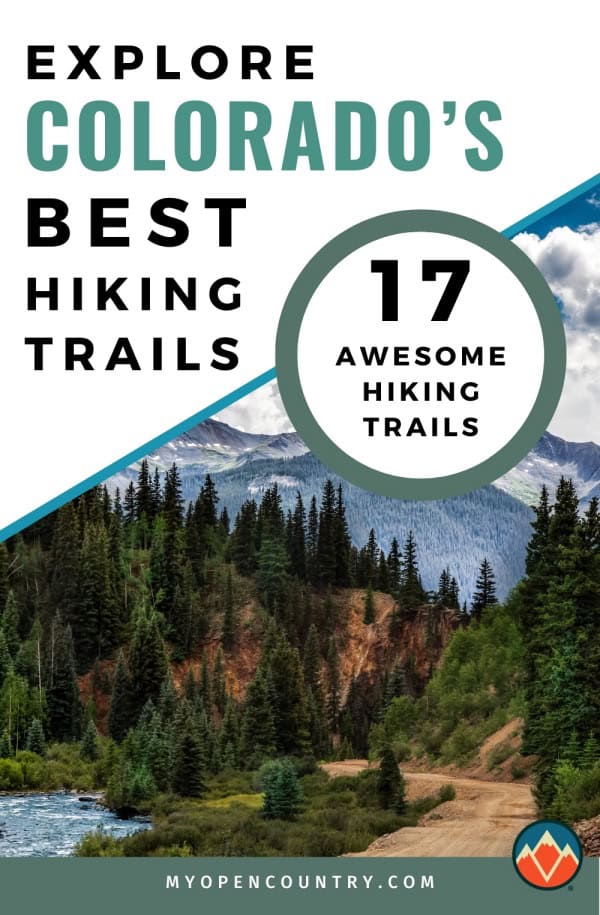
Save for later!!! ⤵️
Table of Contents
- 1. Blue Lakes Trail
- 2. Emerald Lake Trail, Rocky Mountain National Park
- 3. Warner Point Nature Trail, Black Canyon of the Gunnison National Park
- 4. Fountain Valley Trail, Roxborough State Park
- 5. South Colony Lakes Trail
- 6. Monarch Lake Loop
- 7. Sky Pond via Glacier Gorge Trail, Rocky Mountain National Park
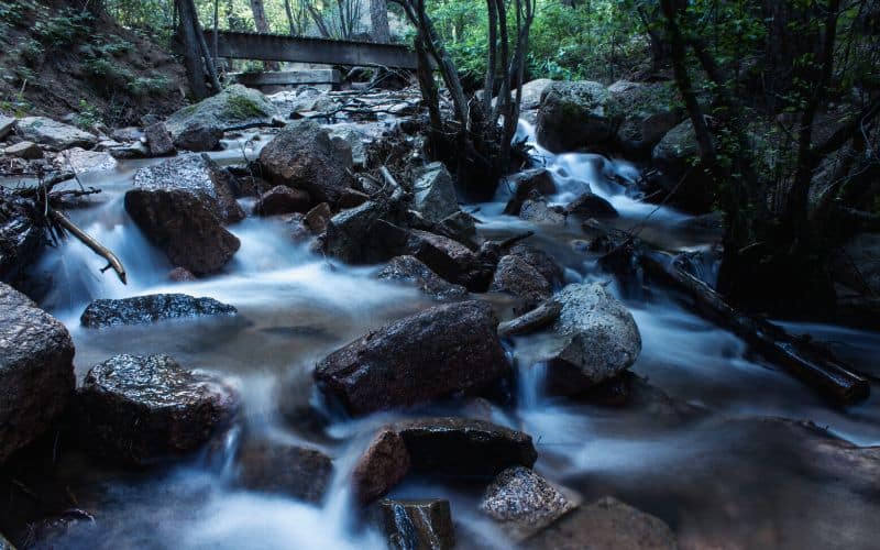
- 8. Upper Fish Creek Falls
- 9. Royal Arch Trail, Boulder
- 10. Crater Lake, Cascade Creek Trail
- 11. Seven Bridges Trail
- 12. The Colorado Trail
- 13. High and Star Dune Loop, Great Sand Dunes National Park and Preserve
- 14. First and Second Flatirons Loop
- 15. Longs Peak Keyhole Route
- 16. Palmer Trail Loop, Garden of the Gods (Colorado Springs)
- 17. Hanging Lake Trail
- Best Hikes in Colorado: Happy Hiking!
1. Blue Lakes Trail
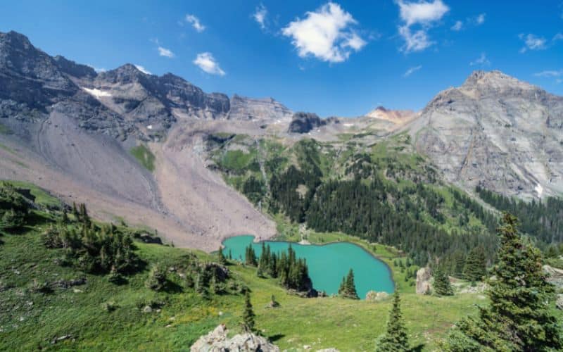
- Type: Out and back
- Length: 8.7 miles
- Difficulty: Moderate to challenging
Even seasoned hikers agree Blue Lakes Trail leads to some of the most beautiful alpine lakes in the state. But as the saying goes, “Nothing worth having comes easy.” This is one of those Colorado hikes that will have you questioning your hobbies and abilities.
Even getting to the trailhead is difficult and requires a higher-clearance vehicle with at least all-wheel drive. Follow Dallas Creek Road to a dead end and start your hike with a climb through a peaceful pine forest.
The first alpine lake, Lower Blue Lake, is three and a half miles from the trailhead. This leg of the hike is moderate, and most people turn around after the first lake.
The trek becomes increasingly difficult as it ascends to the other two lakes and a mountain pass. Whether you hike to the mountain pass or not, Blue Lakes is a classic Colorado trail that we cannot recommend highly enough.
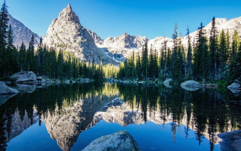
2. Emerald Lake Trail, Rocky Mountain National Park
- Type: Out and back
- Length: 3.2 miles
- Difficulty: Easy
Emerald Lake Trail is a Rocky Mountain National Park must-do and is appropriate for most skill levels and ages. The trail takes hikers past alpine lakes and dramatic mountain scenery.
Start from the Bear Lake Trailhead (the earlier, the better – this is a very popular hike), and follow the path into an aspen and ponderosa pine forest. Nymph Lake, Dream Lake, and Emerald Lake are spaced about a half mile apart along the path.
Each lake offers stunning views, but Emerald Lake is the crown jewel, surrounded by the towering rock walls of Flattop Mountain and Hallett Peak.
If you wish to extend your hike and get away from the crowds, check out the Lake Haiyaha Trail. You’ll find the turnoff for this trail at the one-mile mark of the Emerald Lake Trail.
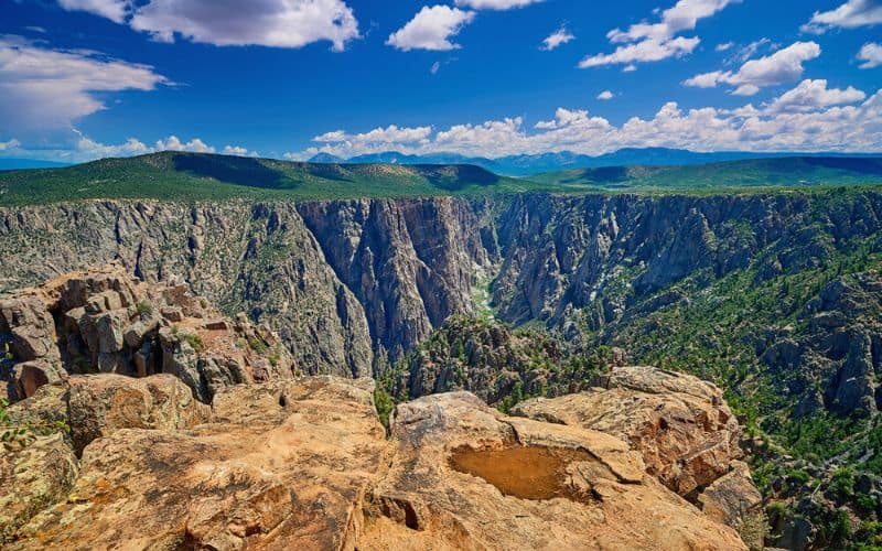
3. Warner Point Nature Trail, Black Canyon of the Gunnison National Park
- Type: Out and back
- Length: 1.5 miles
- Difficulty: Easy
The Warner Point Nature Trail provides stunning views without a body-breaking hike. This makes it ideal for families, beginners, and everyone who wants to enjoy a taste of the desert and canyon side of Colorado.
Find the trailhead at the end of South Rim Road in Black Canyon of the Gunnison National Park. From November to April, check road conditions before you go, as snow can sometimes close the road. When it is accessible, hikers can enjoy the best of the Black Canyon of the Gunnison.
The trail follows the south rim of the canyon and gives hikers a unique look at the sheer canyon walls and winding Gunnison River. You’ll also enjoy expansive views of the West Elk and San Juan Mountains.
At Warner Point, the views are even better as you can look into the deepest part of the canyon and at the desert plateau high above. Kick back on one of the benches to stay a while and soak in the beauty.
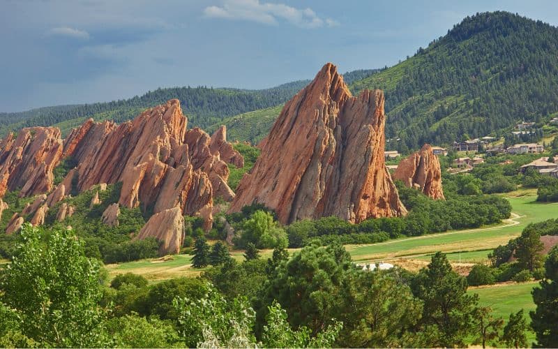
4. Fountain Valley Trail, Roxborough State Park
- Type: Loop
- Length: 2.6 miles
- Difficulty: Easy
Check out Roxborough State Park and Fountain Valley Trail for a convenient day trip from Denver. This easy trail weaves along a valley floor, through a scrub oak forest, and past remarkable rock formations.
The trail loops around some of the state park’s most exciting rock formations, including the Fountain and Lyons formations, large sandstone fins sticking sideways out of the valley floor. You’ll also pass Presse Place, a historic estate. Use the interpretive displays to learn about the building.
There’s more to Roxborough State Park than meandering loop trails. For something more strenuous, try the 6.4-mile slog to Carpenter Peak, or use the South Rim trail for a moderate outing with great views of ‘Denver’s Garden of the Gods.’
The proximity to the city, combined with amazing views, makes this one of the best hikes in the Centennial State there is.
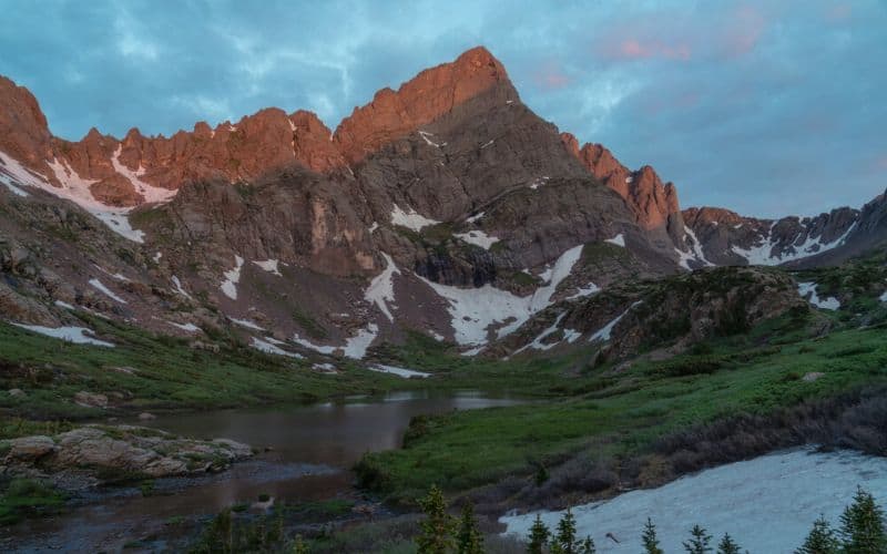
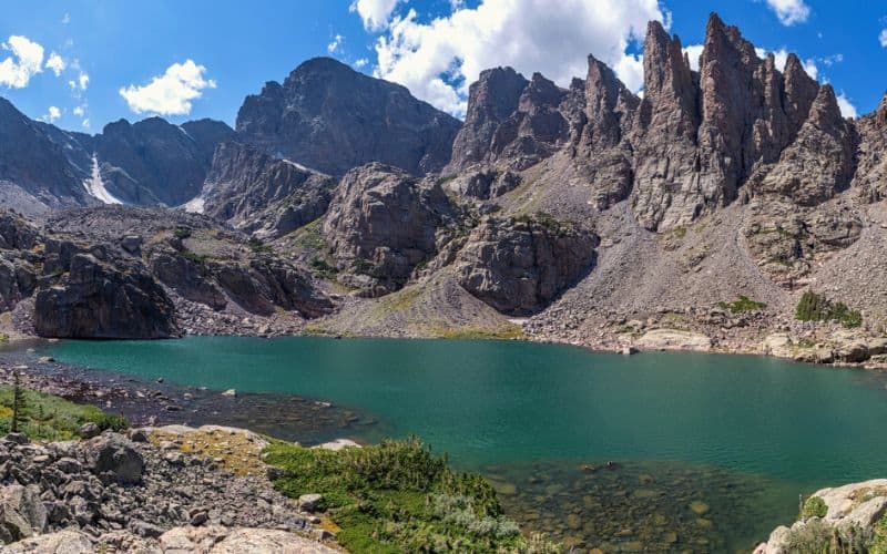
5. South Colony Lakes Trail
- Type: Out and back
- Length: 8.9 miles
- Difficulty: Challenging
South Colony Lakes Trail wows hikers as they climb into the heart of the Sangre de Cristo Mountains. Often used as an approach for summiting 14ers (peaks over 14,000 feet), this one is strenuous!
There are two parking lots for the trailhead, both off County Road 119, south of Westcliffe, Colorado. Getting to the upper lot requires high clearance and four-wheel drive. Starting from the lower lot adds a couple of miles one way.
Once off the road, the real hike begins with some sections exceeding a 30% gradient. This out-and-back hike ends with a 2.5-mile loop around three gorgeous, crystal-clear alpine lakes. We suggest hiking this loop in a counterclockwise direction. Either way, massive mountains dominate the skyline for an unforgettable hike.
“Colorado is an oasis, an otherworldly mountain place.”
Brandi Carlile
Singer-songwriter
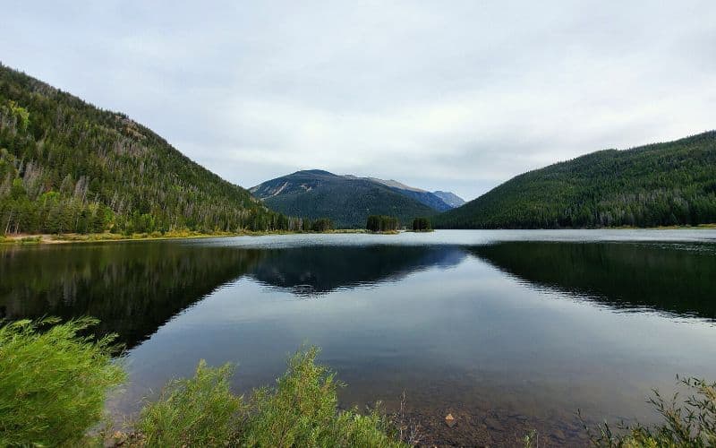
6. Monarch Lake Loop
- Type: Loop
- Length: 4.0 miles
- Difficulty: Easy
The Arapaho National Recreation Area is home to dense forests, grassy meadows, wetland marshes, and the picturesque Monarch Lake. Use the Monarch Lake Loop Trail to experience the best of what the area offers.
Although only 4 miles, this loop is jam-packed with gorgeous scenery and wildlife viewing opportunities. Follow a graded gravel path from the trailhead to a Wilderness Information Cabin. You will find helpful maps and information on the area’s hikes here.
From the cabin, use Cascade Trail #N1 to follow the lakeshore. The trail parallels the lake before passing through a wetland and secluded forest before following the opposite shore back to the trailhead. As you hike, look for wildlife, including osprey, moose, elk, and bobcats.
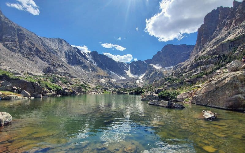
7. Sky Pond via Glacier Gorge Trail, Rocky Mountain National Park
- Type: Out and back
- Length: 9.4 miles
- Difficulty: Challenging
One of the more challenging hikes in Rocky Mountain National Park, Sky Pond, is usually less crowded than the rest of the area. However, expect the first mile from the Glacier Gorge trailhead to be busy, as it leads to Alberta Falls, one of the most photographed spots in the park.
After you’ve admired the crashing 30-foot waterfall, follow signs for Loch Vale, a gorgeous subalpine lake where you can catch your breath. From Loch Vale, the path climbs steeply to the base of Timberline Falls. The next 100 feet of the hike require serious rock scrambling/climbing. If the rocks are wet, consider turning back here.
Take a moment at the top of the scramble at Lake of Glass. Then push through the last 0.4 miles of rugged terrain to Sky Pond and some of the most breathtaking views in the park. Vertical rock walls and alpine meadows encircle Sky Pond. Stay for a while to take it all in before carefully retracting your steps to the falls and trailhead.
8. Upper Fish Creek Falls
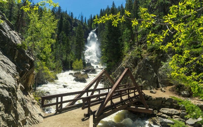
- Type: Out and back
- Length: 4.7 miles
- Difficulty: Challenging
There are many ways to hike the Fish Creek Falls area. Choose your adventure depending on time and experience level.
This scenic hike begins with a 0.3-mile paved trail to an overlook platform and sweeping views of Fish Creek Falls and its canyon.
Next, descend a set of wooden steps to a bridge and an up-close look at the 2nd highest waterfall in the state. To the bridge and back is 0.8 miles and the perfect hike if you’re short on time.
For a longer hike and a chance to see another waterfall, follow the trail up a series of steep switchbacks. Navigate a narrow rock ledge along a cliff face and ascend a ridge before finally arriving at Upper Fish Creek Falls.
You can hike another four miles to Long Lake, but most day hikers take a few moments to appreciate the cascading water before returning to the trailhead.
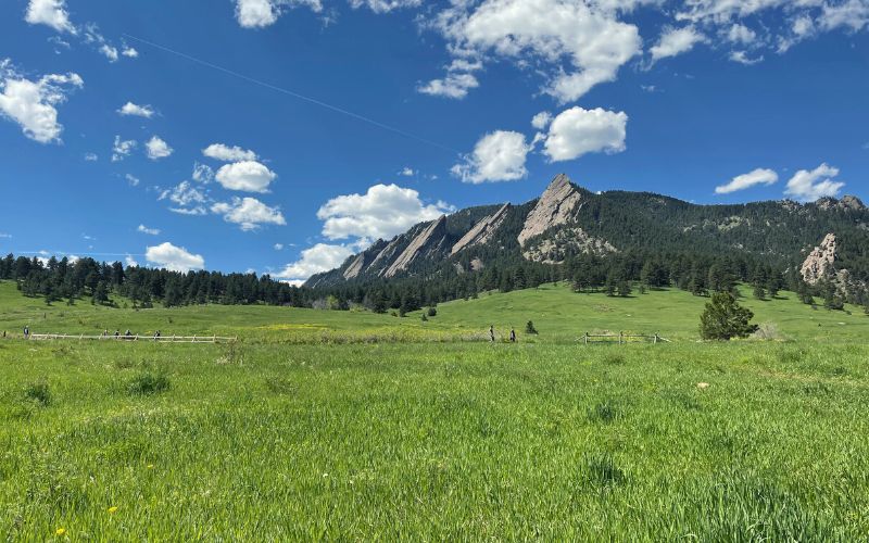
9. Royal Arch Trail, Boulder
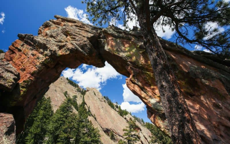
- Type: Out and back
- Length: 3.4 miles
- Difficulty: Challenging
Located in Boulder’s renowned Chautauqua Park, Royal Arch Trail is one of the best hikes in the Front Range. It’s also a popular hike, so start early or avoid crowds by going in the winter.
Park at the Chautauqua Park Trailhead. During peak season, the parking lot fills quickly, so make sure you get there early to secure a spot. The city of Boulder provides a free shuttle from Memorial Day to Labor Day.
Start on Bluebell Road. The trail, which begins near the Bluebell Shelter, is well-marked and easy to find. Don’t be fooled by the first downward section into Bluebell Canyon – you have a hard hike ahead!
As this rocky trail climbs out of the canyon, expect switchbacks, loose rocks, and many stairs. Your legs will be burning by the time you reach the arch, but it’s all worth it. If the 20-foot-tall arch isn’t impressive enough, the hike provides jaw-dropping views of Boulder and the iconic flatirons.
To explore more of Chautauqua, return to Bluebell Shelter, where the park’s many hiking trails converge.
10. Crater Lake, Cascade Creek Trail
- Type: Out and back
- Length: 16 miles
- Difficulty: Challenging
Not to be confused with Crater Lake in the Aspen area, Crater Lake of Indian Peaks Wilderness is just as magnificent but half as crowded, making it one of the top hiking trails in the state for anyone who can deal with high traffic. This 16-mile out and back makes for a long and gratifying day hike or an easy overnight adventure.
The start of this hike overlaps with the Monarch Lake Trail but diverges after a mile. Once you leave the loop, expect things to be quieter and more difficult. Twenty-seven switchbacks cut through rocky terrain and pretty alpine meadows.
Seven and a half miles later, you will arrive at Mirror Lake and serene reflections of Lone Eagle Peak and Mount Achonee. Walk a half mile further to be captivated by Crater Lake.
To camp here, you must have an overnight permit. There are a few established campsites. Dispersed camping is allowed at least 100 feet from trails or water. As with any backcountry visit, always practice Leave No Trace.
11. Seven Bridges Trail
- Type: Out and back
- Length: 3.5 miles
- Difficulty: Moderate
For a scenic creekside hike, try Seven Bridges Trail near Manitou Springs. As the name suggests, this Colorado hiking trail crosses seven bridges, each as photogenic as the last. Don’t forget your phone or camera!
The trailhead is at the end of Gold Camp Road. Be aware that the Seven Bridges Trail is officially called Trail #622 and is marked as such.
The hike begins on a restored narrow gauge railroad before branching off into the woods and becoming rocky and moderately difficult.
The route climbs gradually and consistently as you hike from bridge to bridge, crisscrossing a babbling brook. The soothing sound of running water accompanies hikers for a relaxing and rejuvenating day in the woods.
The trail does continue past Bridge #7 across a steep scree field if you’re up for a challenge, but most day-trippers turn back after the last bridge.
12. The Colorado Trail
- Type: Point to point
- Length: 567 miles
- Difficulty: Expert
As far as thru-hikes go, the Colorado Trail, or CT, might be the most scenic in the country. This 567-mile trail passes through six wilderness areas and spans eight mountain ranges with an average elevation of 10,300 feet. Total elevation gain for the entire hike is around 89,000 vertical feet. The CT is known for its diverse landscapes, from alpine tundra to dense forests, and offers hikers breathtaking views of Colorado’s iconic peaks and valleys. The trail also passes by numerous pristine lakes and meandering streams, making it an incredibly rewarding experience for outdoor enthusiasts. However, if you’re looking for a completely different hiking experience, consider exploring the best Sedona hiking trails, known for their stunning red rock formations and desert scenery.
The Colorado Trail Foundation recommends thru-hiking between July 1 and September 30 and giving yourself 4-6 weeks to complete the route. Luckily, there are other ways to enjoy the trail.
The CT is broken into 33 segments, with trailheads at the beginning and end of each. This breakdown makes day trips, section hikes, and backpacking trips a breeze. For example, Segment 5 from Long Gulch to Kenosha Pass is a moderate 14.6-mile hike. Most point-to-point hikers shuttle a vehicle to avoid backtracking.
Try Segment 7 from Gold Hill Trailhead to Copper Mountain for a more challenging but incredibly scenic hike. Combine Segments 7 and 8 for an idyllic one-night backpacking trip. Whether you hike one segment or the whole CT, ensure you’re prepared with all the right gear and information.
13. High and Star Dune Loop, Great Sand Dunes National Park and Preserve
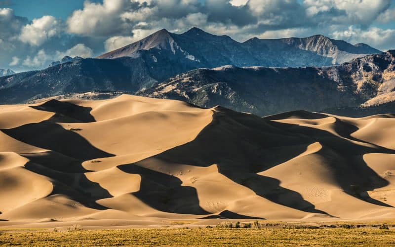
- Type: Loop
- Length: 8 miles
- Difficulty: Challenging
Great Sand Dunes National Park and Preserve in southern Colorado boasts the largest sand dunes in North America. Walking the dunes is like being transported to another planet. Use the High and Star Dunes Loop to discover the grandeur of the dunes and surrounding rocky mountains.
After you enter the National Park, make your way to the Dunes Parking Lot and begin your hike. Be warned, hiking in the sand is difficult and slow-moving. During the summer, the sand can reach 150°F. Leave the sandals in the car and lace up your hiking boots for this one.
Even though elevation gain is minimal, the going is tough, but you will be rewarded with some of the most intriguing scenery in the state. Going as far as High Dune is enough to experience the undulating dunes and the striking Sangre de Cristo Mountains in the background.
Even if you don’t plan on the 8-mile loop, the Great Sand Dunes can be unforgiving. Bring lots of water and always wear sun protection.
14. First and Second Flatirons Loop
- Type: Loop
- Length: 2.7 miles
- Difficulty: Moderate
Scaling a flatiron is a Colorado rite of passage. The best way up these sandstone pillars is on the First and Second Flatirons Loop out of Chautauqua Park. As with any hike in the park, it’s best to start early, on a weekday, or during the off-season to beat the crowds.
Even on busier days, this hike is picture-perfect from start to finish. First, the trail winds its way through a grassy meadow. Then ascends into a forested area between the first and second flatiron. This section is responsible for the moderate rating. Be prepared for steep, rocky terrain and uneven footing.
Continue to a saddle behind the sandstone flatiron rock formations, where you are afforded wonderful vistas of the Rocky Mountains and the town of Boulder. To complete the loop, take Bluebird Mesa Trail through a dense pine forest and back to the trailhead.
15. Longs Peak Keyhole Route
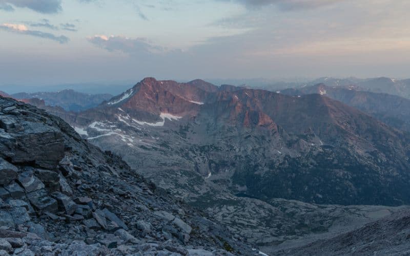
- Type: Out and back
- Length: 14.5 miles
- Difficulty: Challenging to Expert
Rocky Mountain National Park Service warns that the Keyhole Route up Longs Peak is “not a hike.” A lot of the route requires focused scrambling and climbing on exposed cliff faces where rockfall is likely, and a misstep could be fatal. This route should not be taken lightly.
‘The Keyhole Route is not a hike. It is a climb that crosses enormous sheer vertical rock faces, often with falling rocks, requiring scrambling, where an unroped fall would likely be fatal. The route has narrow ledges, loose rock, and steep cliffs.’
National Park Service
U.S. Department of the Interior
 National Park Service
For expert hikers, the Keyhole Route can be the experience of a lifetime. This hike begins at the Ranger Station and follows East Longs Peak Trail up to 12,800 feet, where the trail disappears. Use cairns to navigate as you scramble through the Keyhole, the Trough, the Narrows, and the Homestretch on your way to the 14,259-foot summit.
If everything goes well, the feelings of accomplishment are as grand as the views. Longs Peak stands above its peaks and offers unrivaled views of the Rocky Mountains. It’s like standing on top of the world!
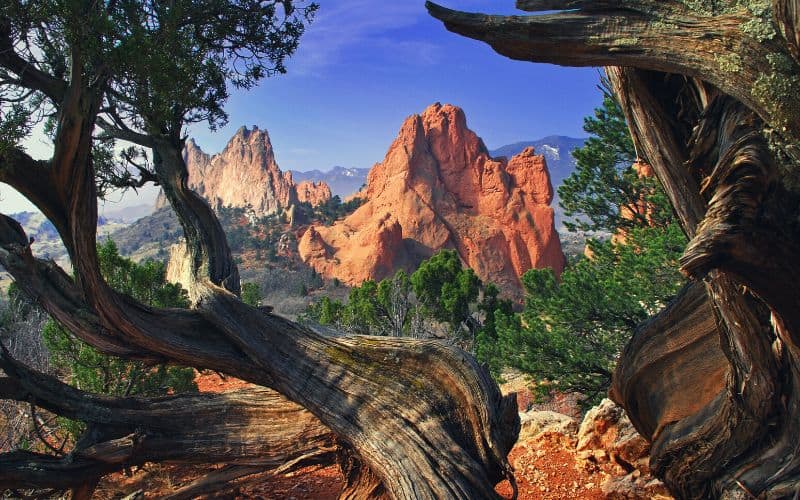
16. Palmer Trail Loop, Garden of the Gods (Colorado Springs)
- Type: Loop
- Length: 1.8 miles
- Difficulty: Easy
No trip to Colorado is complete without a stop at the Garden of the Gods. This Colorado Springs city park attracts 4 million visitors each year. People come from around the world to walk among the soaring red rock formations.
The Palmer Loop is one of many hiking trails in the park, but the best for getting an overview of the park’s best features.
Your first stop should be the Visitor Center, where you can pick up a map and learn about the area. The hike begins from the main parking lot.
Palmer Loop takes hikers through the legendary Central Garden, home to 300-foot-tall rock slabs. From there, you’ll leave the pavement and crowds for nearby meadows and foothills that provide a new vantage point of the famous free-standing rocks and the surrounding landscape.
The loop ends shortly after the fascinating Siamese Twin rocks. Use the Susan G. Bretag Trail to loop back to your vehicle.
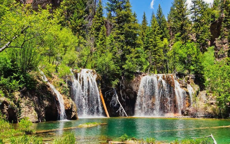
17. Hanging Lake Trail
- Type: Out and back
- Length: 3.1 miles
- Difficulty: Moderate
Hanging Lake near Glenwood Springs has been a Colorado favorite as far back as 1910. The travertine waters and surrounding scenery make Hanging Lake an enchanting place and a must-see in the state whether you’re a hiker or not!
As you can imagine, this is an incredibly popular trail. So much so that since 2019 hiking to Hanging Lake requires a permit.
Permits are $12 per person in the summer and $10 in the winter, including your parking pass. Whatever the fee, it’s a small price to pay. Once you have your permit, go to the trailhead at the Hanging Lake Rest Area right off Interstate 70.
The trail includes a few steep sections as it ascends Glenwood Canyon. There are handrails placed along the path to help navigate the rocky terrain. Don’t be afraid to use them and take breaks as needed.
If the hike doesn’t steal your breath away, the views of Hanging Lake will. Waterfalls cascade from high cliffs into turquoise-colored water. A path encircles the lake so you can enjoy it from multiple angles. This is where we recommend having lunch before heading back to the trailhead.
Best Hikes in Colorado: Happy Hiking!
Outdoor enthusiasts everywhere dream of Colorado hikes. You can scale sheer rock faces, swim in alpine lakes, and explore miles of sand dunes all in the same state. There is truly something for everyone. If you’re looking for even more adventure, New Mexico outdoor adventures are just a short drive away. With its diverse landscape of desert canyons, snow-capped mountains, and ancient ruins, New Mexico offers a whole new range of outdoor activities to explore. You can try your hand at rock climbing in the Sandia Mountains, go backpacking in the Gila Wilderness, or visit the otherworldly White Sands National Park. The options for outdoor exploration in this region are truly endless.
We hope our guide to the best hikes in Colorado inspires you to head out there and experience the Centennial State’s epic hiking trails. If you’re looking for some unmissable trails near Boulder, consider exploring the stunning landscapes of the Flatirons or venturing to the Royal Arch. These trails offer breathtaking views and a chance to immerse yourself in Colorado’s natural beauty. Whether you’re an experienced hiker or a novice, there’s something for everyone in the heart of the Rocky Mountains.
Share this post with your hiking partner, and let us know which hike is your favorite in the comments below!
Save for later!!! ⤵️

Great list and informative read!