
Downtown Las Vegas is best known for its strip of world-class entertainment venues: casinos, bars, pools, concert halls, and so much more. However, if you’re a keen outdoor enthusiast, then you’ll be happy to know that within a thirty-minute drive of Las Vegas, you can access some of the most incredible sandstone rock formations and hot springs in the country.
Whether you’re hiking in the Red Rock Canyon, the Valley of Fire State Park, around Lake Mead, or in the Sloan Canyon, the outskirts of Sin City have so much – if not more – entertainment for hikers.
Pack those hiking shoes, hat, and sunscreen, and discover the best of them in our guide!
Table of Contents
- 1. Ice Box Canyon, Red Rock Canyon
- 2. Calico Hills, Red Rock Canyon
- 3. Calico Tanks, Red Rock Canyon
- 4. Las Vegas Overlook Trail
- 5. White Domes, Valley of Fire State Park
- 6. Fire Wave Trail, Valley of Fire State Park
- 7. Arizona Hot Springs Trail, Lake Mead
- 8. Upper and Lower Bristlecone Loop, Spring Mountains National Recreation Area
- 9. Mary Jane Falls, Spring Mountains National Recreation Area
- 10. Black Mountain Trail
- 11. Petroglyph Trail, Sloan Canyon National Conservation Area
- Best Hikes Near Las Vegas: Time to Go Party… on the Trail!
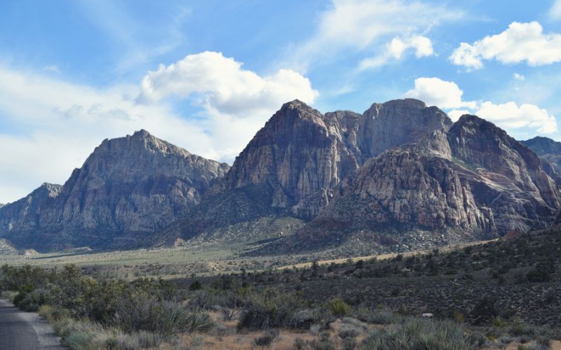
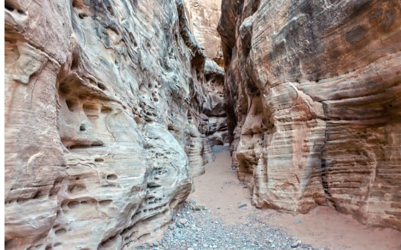
1. Ice Box Canyon, Red Rock Canyon
- Type: Out and Back
- Difficulty: Moderate
- Length: 2.2 miles
Many people laugh at the name of this canyon. An ice box, in the middle of the blazing hot desert? While not icy, the Ice Box Canyon is a beautiful trail in the heart of the Red Rock Canyon National Conservation Area. There are interesting rock formations, bits of mild rock scrambling, and the canyon provides a great respite from the heat!
The desert views begin before the hike. Once you enter the conservation area, the park’s scenic drive brings you on a loop. The trailhead is at the 10-mile mark.
From the parking lot, follow the green-arrowed waymarkers. The crag faces and canyon walls rise above you in the distance. As you get closer to them, the trail steepens.
Soon, you reach a junction. Different rock staircases and paths of varying difficulty bring you to the wash, then the seasonal waterfall. Enjoy these cooler temperatures! Although short, this popular trail makes for a rewarding hike.
We recommend wearing shoes with good traction. It can be slippery in the canyon.
This out-and-back hike is also very popular, so start early to beat the crowds and find parking.
At the time of writing, there is a $15 fee to access the Red Rock Canyon National Conservation Area. Reservations are mandatory between 31 October and 31 May.
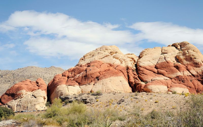
2. Calico Hills, Red Rock Canyon
- Type: Out and Back
- Difficulty: Moderate/Strenuous
- Length: 2 miles
This is one of the most popular nearby trails and with good reason.
Red and cream-colored rocks, Aztec sandstone, varied formations and textures, and rock climbers galore – this moderate trail gives hikers a different perspective on the landscape surrounding the city.
The main trail starts off the Scenic Drive, in either the Calico 1 or 2 parking lots. The route we describe her is from Calico 2.
Follow signs towards the canyon until arriving at a junction. Go right.
If you begin to sense that childish need to explore, succumb to it. Unlike the distractions and lights of the city, this is nature’s beauty – grand, textured, natural. Relish it. Take your time to explore and indulge your curiosity.
Once you leave this area, follow the massive mesh-filled cairns toward a small ridgeline. Here, the surrounding mountains reveal themselves.
Similar to the Ice Box Canyon Trail, there is a fee to access the Red Rock Canyon National Conservation Area. Reserve ahead of time and book your arrival slot.
3. Calico Tanks, Red Rock Canyon
- Type: Out and Back
- Difficulty: Moderate/Difficult
- Length: 2.3 miles
Of our three Red Rock Canyon day hikes, this is the most challenging trail. But, with the extra strain and effort comes great rewards. If you’re a keen boulderer but your companions aren’t, this is a great compromise – you can climb red rocks and they can hike!
Starting from the Sandstone Quarry parking lot, follow signs for the Calico Tanks Trail. Walk straight through the first junction. If you see people climbing on a big boulder, with mats and pals below, you’re on the right trail!
The moderately difficult trail soon begins to show its teeth. The sand beneath your feet is loose and there are no way markers. Where do you go?
Keep going. At each junction, both well-trodden paths lead toward the big canyon. Once in the canyon, you can only go straight to the Calico Tanks! If you’re uncertain, download the trail map beforehand.
The total elevation gain for this day hike is around 350 feet.
4. Las Vegas Overlook Trail
- Type: Out and Back/Loop
- Difficulty: Moderate/Difficult
- Length: 2/6 miles
Whether you’re in Las Vegas to gamble, party with friends, or celebrate a wedding, leaving the city strip for outdoor activities and to gain height offers a wonderful perspective of the city. Here, on the periphery of Las Vegas valley, you can see how the city lies in the middle of the desert . . . like a crater!
The Las Vegas Overlook Trail meanders alongside the Blue Mountains. There are many different trails here. Most of them start from the Cowboy Trails car park.
A few classic ways up are via the Muffin Boulders, the Fossil Canyon Trail, and Rock Garden Trail.
Regardless of how you ascend, look out for mountain bikers, trail runners, and horseback riders.
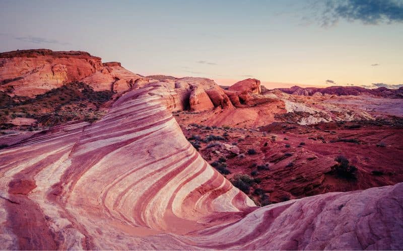
5. White Domes, Valley of Fire State Park
- Type: Loop
- Difficulty: Easy
- Length: 1.1 miles
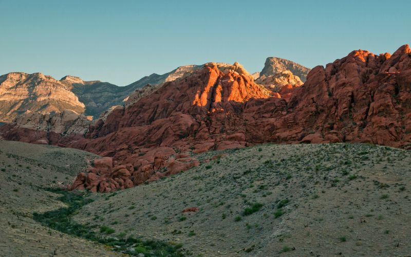
The rocks aren’t ablaze and there are no smoldering ash pits nor giant flames licking the sky, but the White Domes Trail in the Valley of Fire State Park brings you face-to-face with orange and crimson-colored rocks unlike any you’ve ever seen.
This desert hike is great for beginner hikers. It’s relatively flat the whole way and isn’t long. From the parking lot at the end of the White Domes Road, descend until the sandy path flattens. If you see moving spots on the rocks above, fear not – this is a rock-climbing paradise, too!
Look around to see the array of colors: pinks, yellows, white, ochre, auburn, green – this is a unique palette. Mixed in with the shapes of the rocks, you’ll quickly forget about everything else and you’ll be mesmerized.
The White Domes trail brings you past natural arches, overhangs, domes, an old ‘ruin’ that was in fact set up for the film The Professionals, and soon, the narrow slot canyon. The walls here are only a few feet apart.
When you leave, a big sandstone mountain greets you. The contrast between the tight slot canyon and the vista ahead leaves a profound effect.
6. Fire Wave Trail, Valley of Fire State Park
- Type: Out and Back
- Difficulty: Easy
- Length: 1.5 miles
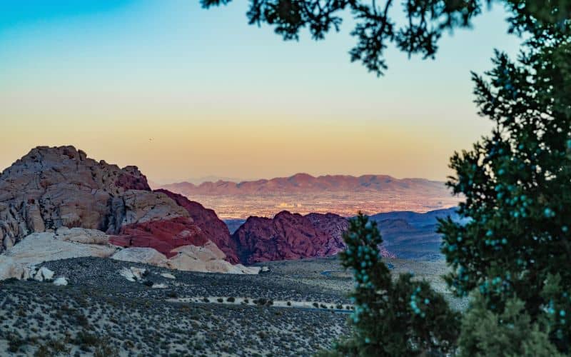
Only thirty minutes further from Las Vegas than Red Rock Canyon, the Valley of Fire State Park offers an abundance of stunning hikes. It is the oldest and largest state park in Nevada, so set your alarm early to make the most of your day here.
This out-and-back hike begins across the street from the White Domes car park 3. The Fire Wave trail is a mix of sand and rock, and you’ll follow small cairns along the way. Soon, you’ll reach the infamous pink, white, and red sandstone fire wave, which looks like a painter’s brush stroke.
The Fire Wave Trail is open year-round, but we don’t recommend going in the summer – the temperature in the desert is well over 100 degrees! There is a $10 entrance fee. As always, to avoid the crowds, hike early.
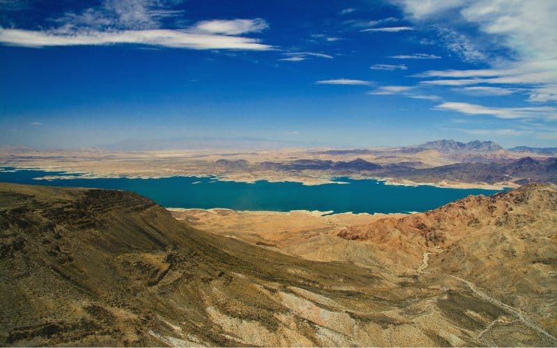
7. Arizona Hot Springs Trail, Lake Mead
- Type: Out and Back
- Difficulty: Difficult
- Length: 5.8 miles
The Arizona Hot Springs Trail is located 40 miles away from Las Vegas along the Colorado River, just south of the Hoover Dam and Boulder City.
This is a rewarding but challenging hike, so shouldn’t be underestimated.
You can get to the hot springs via the White Rock Canyon Trail; however, you’ll need to ascend a short ladder and it may involve very light scrambling. Alternatively, start from a trailhead further down the road and you’ll get to the hot springs from the back.
If you want to make it back to the city with the energy left to party, bring plenty of water and sunscreen, and wear a hat. There is limited cell service, so bring a map.
The fauna along the way is well worth your attention. Amidst this volcanic landscape, you’ll find indigo bush, ground cherry, rabbit brush, desert trumpet, and more.
The area comprises 4 hot springs, surrounded by purple, pink, white, and orange walls. Each natural pool is a different temperature.
It’s important to note the Arizona Hot Springs Trail is closed between 15 May and 30 September. Temperatures here are burning, reaching 120 degrees, and the area is subject to flash floods. This is a popular trail, so leave in the early morning.
There are also rattlesnakes in the desert, so tread carefully.
8. Upper and Lower Bristlecone Loop, Spring Mountains National Recreation Area
- Type: Loop
- Difficulty: Moderate/Difficult
- Length: 5.7 miles
If you love rare species of trees, butterflies, and simply the clean air, then this hike is for you! Weaving through ponderosa pines, aspens, firs, and rare plant species, this hike serves up stunning scenery each step of the way.
Day hikes can be started from the Upper Bristlecone Trailhead at the end of the Lee Canyon Road, or at the Lower trailhead near McWilliams Campground. Regardless of where you start, this moderate trail leads you to the top of the Lee Canyon and onward toward the Highpoint Ridge, where you can enjoy awesome views of Southern Nevada.
There is very little shade at the high point, so head back below the treeline for some respite.
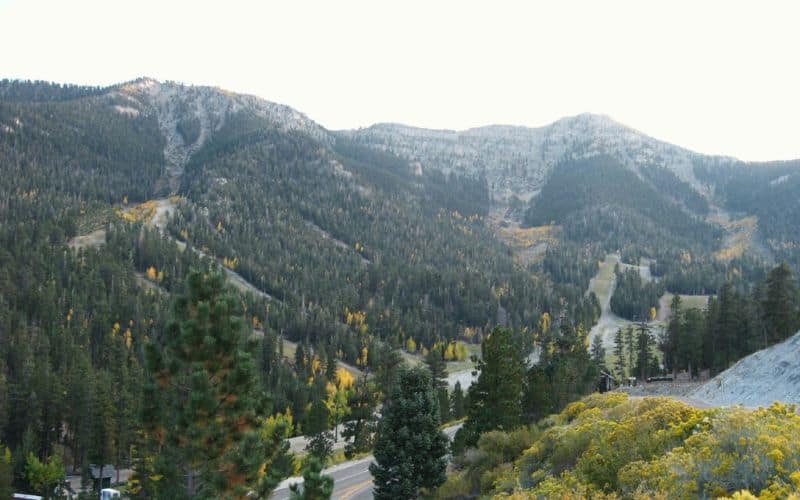
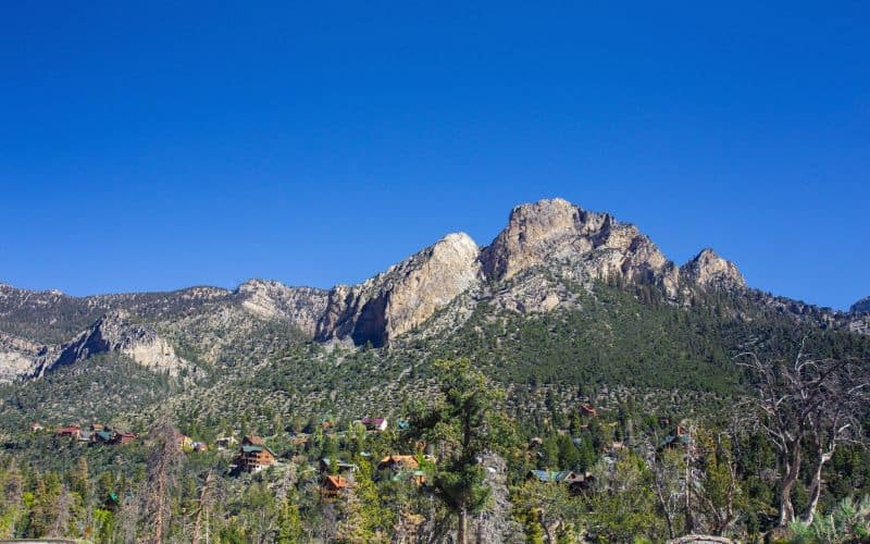
9. Mary Jane Falls, Spring Mountains National Recreation Area
- Type: Out and Back
- Difficulty: Moderate/Difficult
- Length: 3.2 miles
The Mary Jane Falls Trail offers some of the most spectacular views of the landscape near Sin City. From waterfalls to the Mount Charleston wilderness, this day hike is well worth escaping the city for.
From the Mary Jane Falls trailhead, follow the wide trail until you reach a series of gravel switchbacks. These are steep and challenging, but the target ridgeline is just above you, always in sight. At the top, veer left until you reach Mary Jane Falls. They may not seem like big falls, but that’s because they’re dwarfed by the huge walls of limestone rock surrounding them.
Take time to explore the area. There are two caves near Mary Jane Falls, as well as Kyle Canyon and great views over the Mount Charleston area. As the highest peak in the Spring Mountains, Mount Charleston can be seen from various parts of the city strip. Its prominent peak is covered in snow for more than half the year.
If you want to see the Mary Jane Falls roaring, the best time to visit is at the end of spring. However, in winter, these big falls turn into beautiful frozen sculptures.
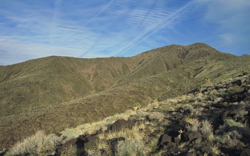
10. Black Mountain Trail
- Type: Loop
- Difficulty: Difficult
- Length: 6.8 miles
The volcanic summit of Black Mountain provides some of the best views around Las Vegas: the city’s strip, Red Rocks, the Spring Mountains, Cathedral Rock, El Dorado, Joshua trees, and much more.
Although the views are great, the mountain itself is noteworthy, for it is clad in black lava cliffs that are very different from the red rock on the other hikes in this guide.
With a total elevation gain of 1,900 feet, the Black Mountain Trail (BLM 404) in the Sloan Canyon area is considered to be one of the more challenging hikes in the area. It is mellow until the last mile; however, light scrambling from here is required to attain the summit.
Due to recent infrastructure work in Henderson, it is now far more difficult to find parking for this hike. Get there early!
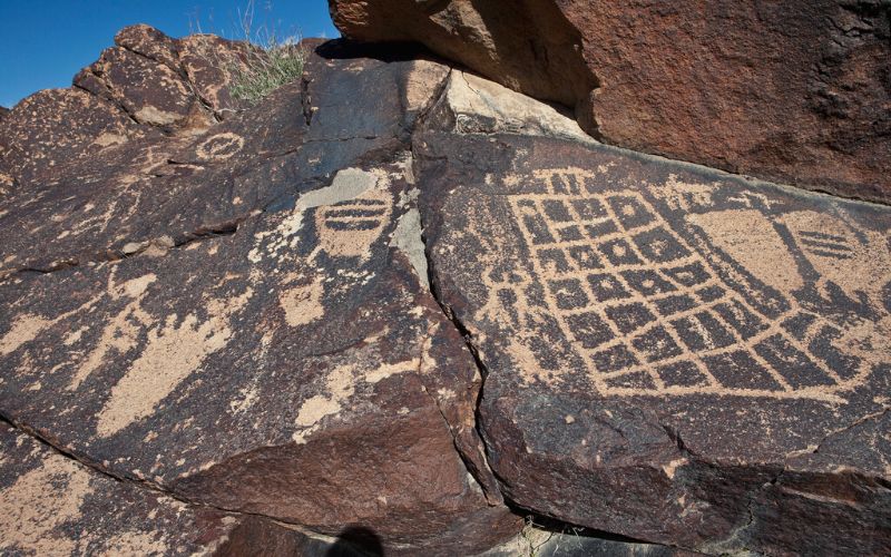
11. Petroglyph Trail, Sloan Canyon National Conservation Area
- Type: Out and Back/Loop
- Difficulty: Easy/Difficult
- Length: 3.6/4.3 miles
Beginning at the Sloan Canyon Trailhead, the Petroglyph Trail (BLM 100) is an out-and-back that can be made into a partial loop. Follow the canyon wash for 2 miles until arriving at Petroglyph Canyon. If you don’t want to scramble into the canyon, bypass via the Cowboy Trail (BLM 200).
Now, before entering the canyon, you pass three dry waterfalls with petroglyphs. These may very well offer insight into each waterfall – people who fell, the roles of the waterfalls, and more. After the third, you enter the main canyon, which has nearly 300 rock art panels! They’re not easy to find and are mostly on small boulders, but once you discover them, they’ll keep coming.
Best Hikes Near Las Vegas: Time to Go Party… on the Trail!
Whether you’re hiking on the infamous Ice Box Canyon trail in the Red Rocks, in the Valley of Fire State Park, or around Lake Mead, there is perhaps more to entertain the keen hiker on the outskirts of Las Vegas than there is in the city itself!
If you enjoyed this article or you know someone looking for the best hikes near Las Vegas, feel free to share this article! Drop a comment or question in the box below.
