Visitors to Los Angeles seeking a little respite from the big-city heat and hustle will struggle to find a more convenient half-day excursion than the hike to Hermit waterfall in the San Gabriel Mountains. This very accessible hike starts a mere 20 miles from downtown LA and over the years has become something of a favorite with local hikers and nature-lovers on account of far more than its proximity to the city alone.
This hike offers a cool, peaceful and leafy retreat that, on quieter days, boasts a feeling of remoteness that belies the 40-minute drive required to get there. As the name suggests, the trail also boasts a bit of a ‘bonus’ feature right in the middle — a 35-foot waterfall and a series of pools that seem custom-made for a paddle or plunge when temps are high.
In this article, we’re going to look at the logistics involved in the hike, from arranging parking permits and getting there to safety advice and what to carry with you on your hike.
We’ll also give you the lowdown on what to expect on the hike and run through a description of the trail from start to finish.
Table of Contents
Trail Overview
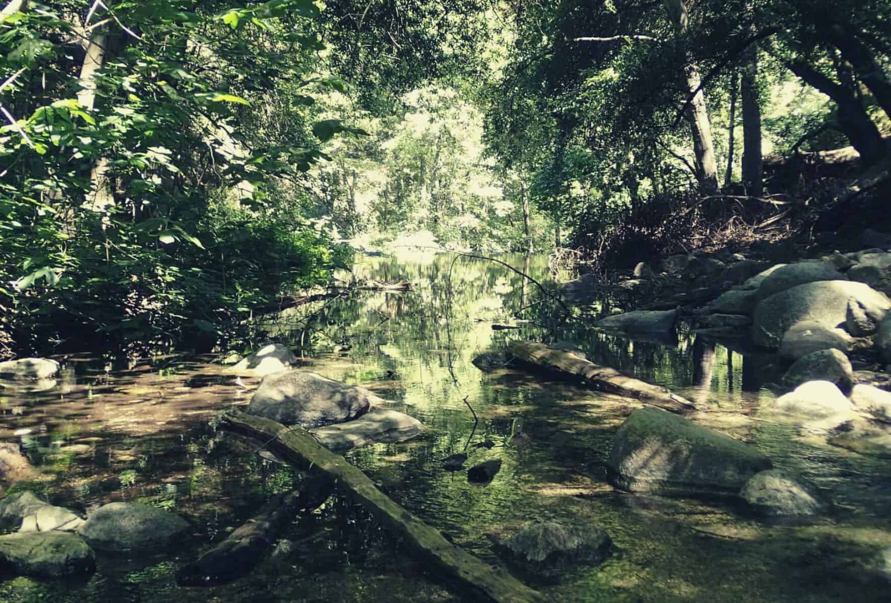
The falls are situated in the lower reaches of Big Santa Anita Canyon in Angeles National Forest’s San Gabriel Mountains. Given their proximity to Los Angeles and accessibility, it’s fairly unlikely you’ll have them all to yourself, particularly on weekends. That said, the trail is far quieter than many others in the area, and a large part of its appeal — and a welcome surprise — is that such a short drive from the metropolis can land you in a spot quite so peaceful, green, and rich in history and natural eye-candy to boot.
Geology/Geography/History
The majority of the trails around Big Santa Anita Canyon were constructed after the discovery of gold in the area in the 1850s. A number of quaint historic cabins and homesteads from that era still line the trail below Chantry Flats and on the Hermit Falls Trail are particularly evident in the hamlet of Roberts Camp.
The origins of Hermit Falls’ name is a matter of some dispute, with some sources claiming it derives from an eponymous cabin built by a gold prospector in 1898 near today’s Big Santa Anita Reservoir and others from the cyclist, hiker and osteopath Marie Riedeselle.
Given the trail’s southern location, the flora and vegetation encountered en route are surprisingly abundant. Oaks, alder, spruce, black sage, Californian sagebrush, ferns and the odd sprig of the relatively rare white sage line the route on either side between the lower switchbacks on the First Water Trail and the trail’s terminus at the falls proper.
Although the trail was originally created as a logging route, the establishment of Angeles National Forest in 1908 spared the area’s array of lofty, shade-giving perennials the wrath of the loggers’ saws in the nick of time.
Type of trail
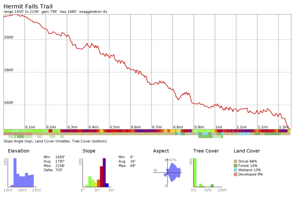
This is a short out & back hiking trail (3-mile round trip), but features that topsy-turvy quirk of canyon hiking that is going down before you go back up, so make sure you save a little bit of gas for the return. At the base of the canyon, the tiered pools and rock clefts offer bolder visitors the opportunity for a spot of optional intro-level canyoneering and scrambling.
Difficulty
The trail is easily negotiable (for experienced hikers) in all seasons, but particular care must be taken after a heavy rainfall or when conditions are wet underfoot. Small sections of the lower trail are fairly narrow and exposed and the rockier portions become scarily slick with even the slightest precipitation.
https://www.instagram.com/p/BEMO_qYtUN4/?utm_source=ig_embed
Although this trail is well-established, it still retains an ‘undesignated’ status with the Forest Service. This, we assume, is largely due to the prevalence of incidents there in recent years.
The total ascent/descent is a moderate 650 feet, with the trailhead starting at 2,180 feet and the falls situated at 1,430 feet.
The duration of the hike is roughly 1.5 hours, without breaks.
Planning
No specific planning is required for a visit to the falls unless you want to pick up an Adventure Pass (see Permits, below) in advance.
One point well worth noting is that the gate on the access road to Chantry Flats is open 6am-8pm every day. To avoid being forced into an involuntary overnighter, make sure you return to your car by 7:45 pm. If you do happen to return late or want to check the road is open following a forest fire or heavy rainfall, call the Sierra Madre Police Department (the key holders) on 626 355 1414.
Best Time to Hike the Trail
There is no bad time to hike the Hermit Falls Trail. In spring and summer months the lush vegetation adds a touch of aesthetic appeal to the area’s existing charm but visits in winter and fall are more likely to be rewarded with a quieter time of things and less of those dive-bombing cliff jumpers.
Permits
No permit is required for hiking, but for the access road you’ll need to pick up (or buy online) a $5 Day or $30 annual Adventure Pass. These can be bought at the Pack Station just above the last parking lot in Chantry Flats. Alternatively, you can grab a pass in advance at sports stores such as REI or Big 5 Sporting Goods, and other retailers such as the ARCO/AMPM gas station at 5 W Foothill Blvd. in Arcadia.
Chantry Flats Parking Tips
Please note that wherever you happen to park in the Angeles National Forest, the authorities are true sticklers for precision parking. Make sure you display your ticket and park within the white lines — we’ve seen tickets handed out for tires merely brushing the edges of the paint!
Trailheads
To get to the trailhead, take Freeway 210 to Arcadia, just east of Pasadena. Take Exit 32 for Santa Anita Avenue and then go north at the end of the off-ramp. Continue up Santa Anita Avenue for approximately 5 miles until reaching the road end at Chantry Flats.
The trailhead coordinates are: 34.1955, -118.0225 (34° 11′ 43.8″N 118° 01′ 21″W)
Shuttle/transportation
There are currently no means of public transportation to or from the trailhead. A pilot shuttle service served Chantry Flats in 2016/17, but at the time of writing the Forestry Service has not announced plans to renew the service for 2018.
Hermit Falls Trail Route
From the parking lots at Chantry Flats, descend on the asphalt road toward Roberts Camp. Approximately 0.2 miles from the parking lots, turn right onto the signposted First Water Trail. Follow the winding switchbacks down into Santa Anita Canyon, reaching the forested, creek-side section of the trail after around 15 minutes.
After another 0.55 miles, the trail reaches the leafy, shaded bottom of the canyon. Here, take a right turn and continue south through the cabins of Roberts Camp.
https://www.instagram.com/p/BVYChxnBBzs/?utm_source=ig_embed
A few hundred yards from Roberts Camp, the trail ends abruptly at a small, man-made dam. Cross the creek on the small causeway of rocks, taking care if they are wet or water levels are particularly high, then continue on the trail heading downstream.
This section of the trail is particularly teeming with flora and vegetation and continues for half a mile to the top of Hermit Falls. The trail crosses over the creek again (may require wading in spring months) and passes a handful of historic cabins and homesteads before climbing the east bank of the creek and finally dropping back down to the upper pools.
The established trail stops short of the main pool at the base of the falls. To reach this, you can either clamber down the steep rock or through the vegetation either side of the falls (a tricky proposition) or undertake the popular — but risky — rite of passage that is a cliff-dive into the pool itself. For safety reasons, we wouldn’t recommend either unless water levels are high and you are confident you will be able to scramble back up to the top of the falls.
Trails Tips
For those of you not keen on the scramble, the two pools above the falls make for more than adequate swimming holes. When water levels are high enough, moreover, a natural water slide into these pools is formed over the mossy rock above. Your inner child will high five you for giving it a go…
https://www.instagram.com/p/BS_aPulDKUC/?utm_source=ig_embed
Good to Know, Gear List & Resources
Good to Know
- Other waterfalls you can visit in the San Gabriel Mountains include fish canyon falls, Switzer Falls, Millard Falls, and Monrovia Falls. Alternatively, hit the Laguna Beach Wilderness hiking trails for some coastal scenery.
- A visit to Hermit Falls can easily be combined with a hike to Sturtevant Falls or on other trails in the area, such as the Santa Anita Canyon Loop
- Camping is available at Hoegee’s Campground, Sturtevant Campground, or Spruce Grove Campground
- Dogs are permitted on the hike
- Bikes are permitted on the trails in Big Santa Anita Canyon, but the Hermit Falls Trail isn’t particularly suitable for mountain biking
Suggested Gear List
Resources
https://www.fs.usda.gov/Internet/FSE_DOCUMENTS/stelprdb5373461.pdf – A list of trails in Big Santa Anita Canyon and a useful trail map
https://www.fs.usda.gov/alerts/angeles/alerts-notices – Information on road closures and other safety alerts
https://www.youtube.com/watch?v=1jreR8UO3q8 – A video to whet your appetite for the hike!
