From unsightly and unpromising beginnings to a spectacular and serene ending, Los Angeles County’s Fish Canyon Trail is a hike of stark contrasts.
Situated on the periphery of the San Gabriel Mountains National Monument and just two miles from the nearest freeway, this popular trail quickly abandons the tarmac and grating machinery of the large, active quarry that envelops its trailhead. From there, it snakes its way into something of a wonderland of lush vegetation, babbling creeks, and towering waterfalls.
It’s a short trail (4.8 miles return) but manages to pack in a great deal of exquisite natural scenery and features nonetheless. Just a ¾-mile hike up the canyon, in fact, and you feel like you’re in the middle of nowhere, not a mere 20 minutes from one of the world’s largest metropolises and another 20 from that altogether uninspiring trailhead.
In this article, we’re going to run through all the ins and outs of a visit to these falls, starting out with a bit of history and then moving onto a full trail description and some handy tips to help you make the most of your time there.
Table of Contents
Overview
Intro
Given its unconventional first three-quarters of a mile, many first-time visitors to Fish Canyon will experience brief bewilderment at the Fish Canyon Trail’s popularity and the various efforts that have gone into rebuilding, maintaining, and gaining access to it over the years. Those efforts have, indeed, become something of a saga, but one that bears testimony to the beauty and allure of what lies beyond the heavily mechanized ruckus at the trail’s outset.
History
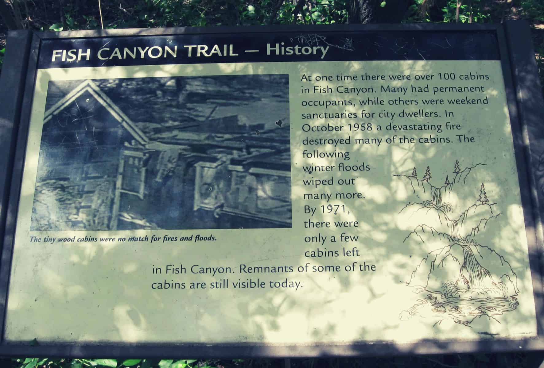
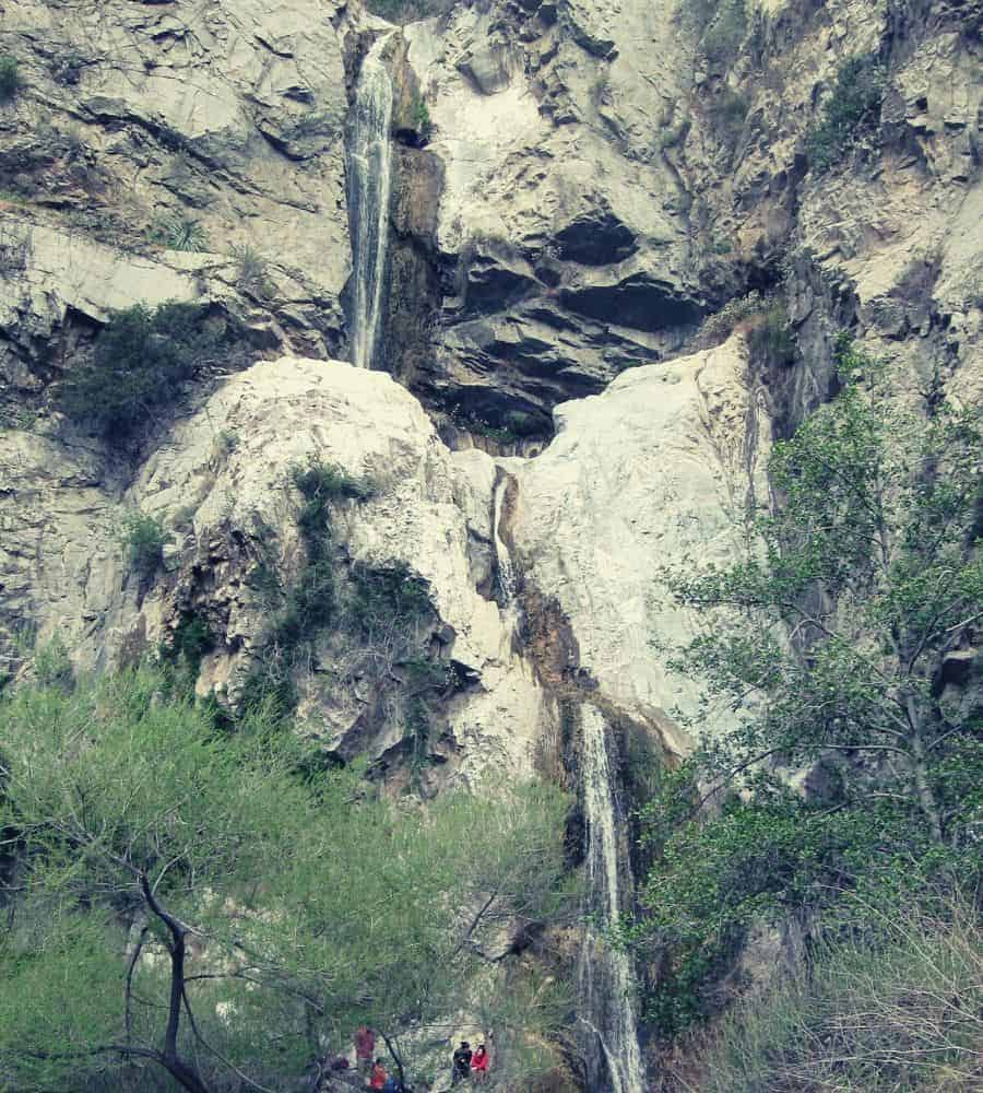
Fish Canyon’s history is one besmirched by a number of incidents that have rendered the stunning 80-foot falls in its depths inaccessible for much of the last hundred years. From wildfires and rockfalls to access rights litigation and quarrying of the surrounding mountains, the area has seen a bit of it all.
In the 1900s, Fish Canyon became popular as a getaway for Angelenos on account of its proximity to the city and natural beauty alike. Most visitors to the canyon today will be surprised to learn that it soon became something of a vacation resort, with over 100 cabins lining its gentler flanks and the banks of Fish Canyon Creek. It even boasted a dancehall at the entrance to the canyon proper, not far from where the Vulcan Quarry operates today.
A huge fire wracked the area in 1958 and was followed by severe flooding in 1959, during which most of the cabins were destroyed. By 1971, only a handful of cabins remained and were soon removed, though the remains of a few stone foundations are still visible along the trail to this day.
In the late 1980s, the Azusa Rock Quarry expanded its operations into the area around the falls, forcing the City of Duarte to establish a somewhat elaborate 9-mile access trail to the falls over the Van Tassel Ridge, a route that failed to endear many locals.
A shorter, more direct trail to the falls was finally opened to the public in the summer of 2014, but only after several years of litigation between the City of Duarte and Vulcan Materials and a short-lived trial of running a shuttle bus through the quarry.
The trail was once again closed due to a large rockslide in December 2015 and then closed ‘indefinitely’ following the San Gabriel Complex Fire, which ravaged the area in the summer of 2016. At the time of writing, efforts to repair the trail are ongoing but a date for reopening has not yet been set.
Ecology
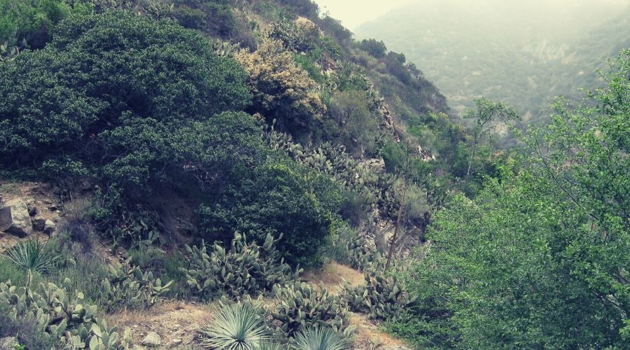
Despite its susceptibility to drought and wildfire, Fish Canyon is home to a large number of wildflowers and tree species and can be surprisingly lush in spring months in particular.
Some of the flora you might find along the trail include larkspur, blue dicks, wishbone bush, sunflowers, tree tobacco, mustard, laurel sumac, California buckwheat, deer weed, brittlebush, Mexican elderberry, western thistle, common sunflower, elegant clarkia, Indian milkweed, prickly pear cactus, bush monkeyflower, Canterbury bells, Spanish broom, and golden yarrow.
Type of Trail and Trail Difficulty
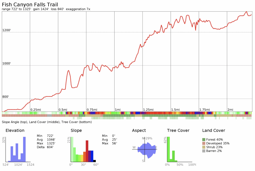
Easy/Moderate: A 4.8-mile out-and-back trail with 835ft of total elevation gain.
Planning
Best Time to Hike the Trail
While the Fish Canyon Falls Trail is open and accessible year-round, the best time to hike is in spring or winter when seasonal rains increase the chances of the falls being in spate. In spring months, moreover, the plant life on and around the trail tends to be more lush and abundant. In summer months, the trail is often too hot for most hikers, with temperatures frequently in excess of 90F.
The trail is open from 7 am to 7 pm from April to September and 7 am to 5 pm from October to March.
Permits
No fee or permit is required to hike to Fish Canyon Falls!
Trailheads
To get to the trailhead at the Vulcan Materials quarry, drive out to the intersection of the 210 and 605 freeways in Azusa, east of Pasadena, and from there take the Huntington Drive exit and head east. Take the third left onto Encanto Parkway and continue to the quarry, which is roughly one mile further ahead. Once you reach the quarry, veer right at the fork and then into the parking area next to the trailhead.
- Trailhead address: 3901 Fish Canyon Road, Azusa, CA 91702
- Trailhead coordinates: 34.15676, -117.92368 (34° 09′ 24.33″N 117° 55′ 25.24″W)
Shuttle/transportation
The City of Duarte runs a free shuttle van between the Fish Canyon Falls Trailhead and the Duarte/City of Hope Gold Line station on Saturdays in April and May only. The service departs every half hour during trail opening hours. The shuttle stop can be found on the west side of Highland Avenue next to the Gold Line Station parking lot.
Trail Route
From the parking lot at the Vulcan Materials site, the Fish Canyon Access Trail sets out through the bottom of the quarry between the fencing that surrounds the plant itself.
After a third of a mile, you will pass under a large conveyor belt ferrying rocks down from the mountain above. Shortly ahead (after 0.5 miles), the trail passes a small kiosk and then descends to the edge of Fish Canyon Creek before continuing through a habitat restoration area to the start of the Fish Canyon Falls Trail proper.
Fish Canyon Falls Trail begins at a second kiosk on the boundary of the San Gabriel Mountains National Monument after passing through a fence and crossing Fish Canyon Creek over a metal bridge.
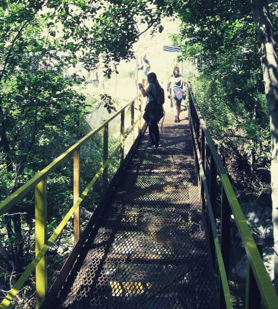
With the unsightly and noisy quarry now behind you, the trail curves along the edge of the creek before a short ascent on switchbacks brings you to a few information posts offering further warnings from the very assiduous folks at Vulcan Materials.
The trail now becomes more densely vegetated and skirts a steep drop down to the creek below. Descending back to the base of the canyon, you will see the scattered ruins of cabins along the edge of the creek and find another information post that reveals that the canyon once hosted over 100 cabins which were year-round residences or vacation homes back in the area’s heyday.
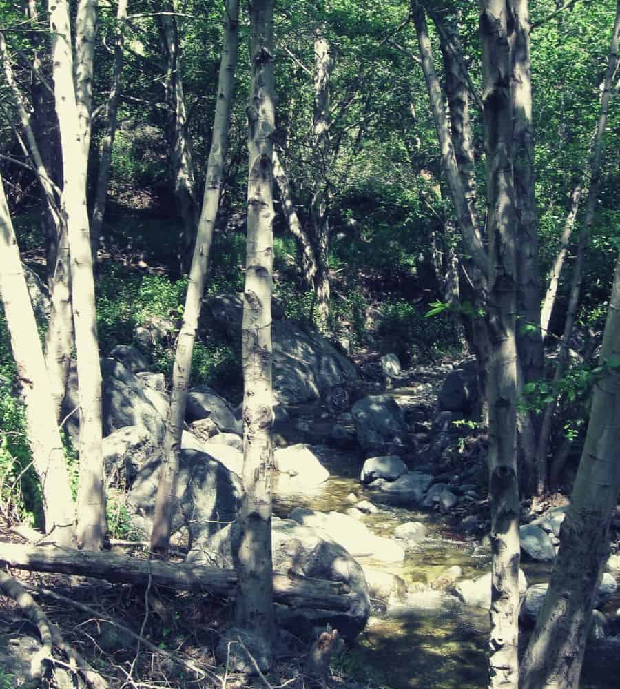
The trail continues along the canyon floor for 0.5 miles before wending gently upwards, passing a handful of pretty rock pools and ever-more-lush and leafy scenery.
Roughly 1.5 miles from the trailhead, a series of steepish switchbacks ascend the canyon’s left flank to the high point of the trail, from where you’ll find the best views up and down the length of the canyon. After another 0.5 miles, the trail descends once more to the side of the creek, skirting the gently flowing water in a pleasantly cool, shaded section of the route before crossing over to the east side of the canyon for the final ascent to the waterfalls (another third of a mile).
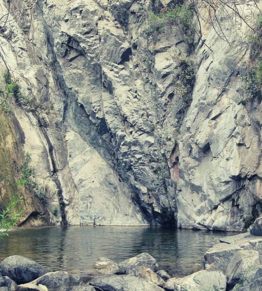
At the base of the falls, there are plenty of spots for sunbathing and/or dunking your trail-toasted feet into the cool water. While it may be tempting to try to reach the pools on the upper tier, this is a tricky proposition and should not be attempted without appropriate rock-climbing gear and ropes.
Good to Know
- Bikes are not permitted on the trail
- Dogs are permitted on weekends but must be kept on a leash
- Trail gates are closed at 7 pm April to September and 5 pm from October to March
- Cars left in the parking lot after hours are towed at the car owner’s expense (!)
- Hikers must stay on the trail while hiking: the land is property of Vulcan Materials and, as such, straying from the trail amounts to trespassing (the signs posted at the start of the trail will leave you in doubt!)
- The falls can be slightly feeble after long dry spells — if you’re keen to see them in spate, head there after a period of substantial rainfall
- Jumping into the pools, as seen in the video below, isn’t recommended unless water levels are exceptionally high (if you can see the water-level mark on the rock wall surrounding the pool, it’s best to leave it for another day)
Suggested Gear List
- Sun hat
- Sunscreen
- First aid kit
- Daypack
- Food
- Water
- Full-length pants
- Hiking boots (recommended owing to the presence of poison ivy, ticks, and occasionally loose rock on the trail)
- Towel (optional)
Additional Resources
- Fish Canyon Access Trail map
- San Gabriel Mountains waterproof topo map
- Azusa Police Department contact number: (626) 812-3200
- Trip report from 2016
