Few short backpacking trails spoil their visitors with quite so diverse and delightful an array of scenery as the trail along the Hoh River in Washington State’s Olympic National Park.
This 17.4-mile trail starts out with a jungle-like feel, wending through moss-laden temperate rainforest before then traversing delectable alpine meadows en route to the pièce de résistance that is the Mount Olympus Blue Glacier. It’s a trail of ever-increasing returns, and one worth every crumb of effort visitors put in both prep and effort-wise.
In this article, we’re going to take you through all you need to know when planning a hike on the Hoh River, starting off with some pre-trip logistics and then delving into the finer details of route descriptions, gear requirements, and a few handy tips to help you make the best of your time on the trail.
Table of Contents
Overview
As fascinating from a historical perspective as it is from an ecological one, the Hoh River Trail bisects an area teeming with intrigue for the nature-lover and history buff alike and in our opinion is one of the best hiking trails in Washington state.
History
Prior to European settlement in the late 18th century, the area surrounding and including what is now Olympus National Park was the home of the Quinault, Queets, Quileute, and Hoh Indian tribes. Early encounters between Europeans and the Hoh were fractious and involved a number of skirmishes both on land and at sea.
Following the establishment of the Washington Territory in 1853, the area’s tribes ceded most of their lands to the US federal government and were relocated to reservations under the 1855 Treaty of Olympia, which was ratified by Congress in 1859.
The environs encompassing today’s Hoh River Trail first gained protected status when President Theodore Roosevelt created Mount Olympus National Monument in 1909. The area was subsequently afforded national park status with the creation of the Olympic National Park by President Franklin Roosevelt in 1938.
A further accolade and layer of formal protection arrived with the park’s designation as a UNESCO International Biosphere Reserve in 1976, as a World Heritage Site in 1981, and then the 95% of the park’s inclusion in the Olympic Wilderness Area created by Congress in 1988.
Geology, Geography, and Ecology
The two most notable highlights of hiking the Hoh River Trail are its teeming vegetation and the Blue Glacier at the trail’s end.
Ecology
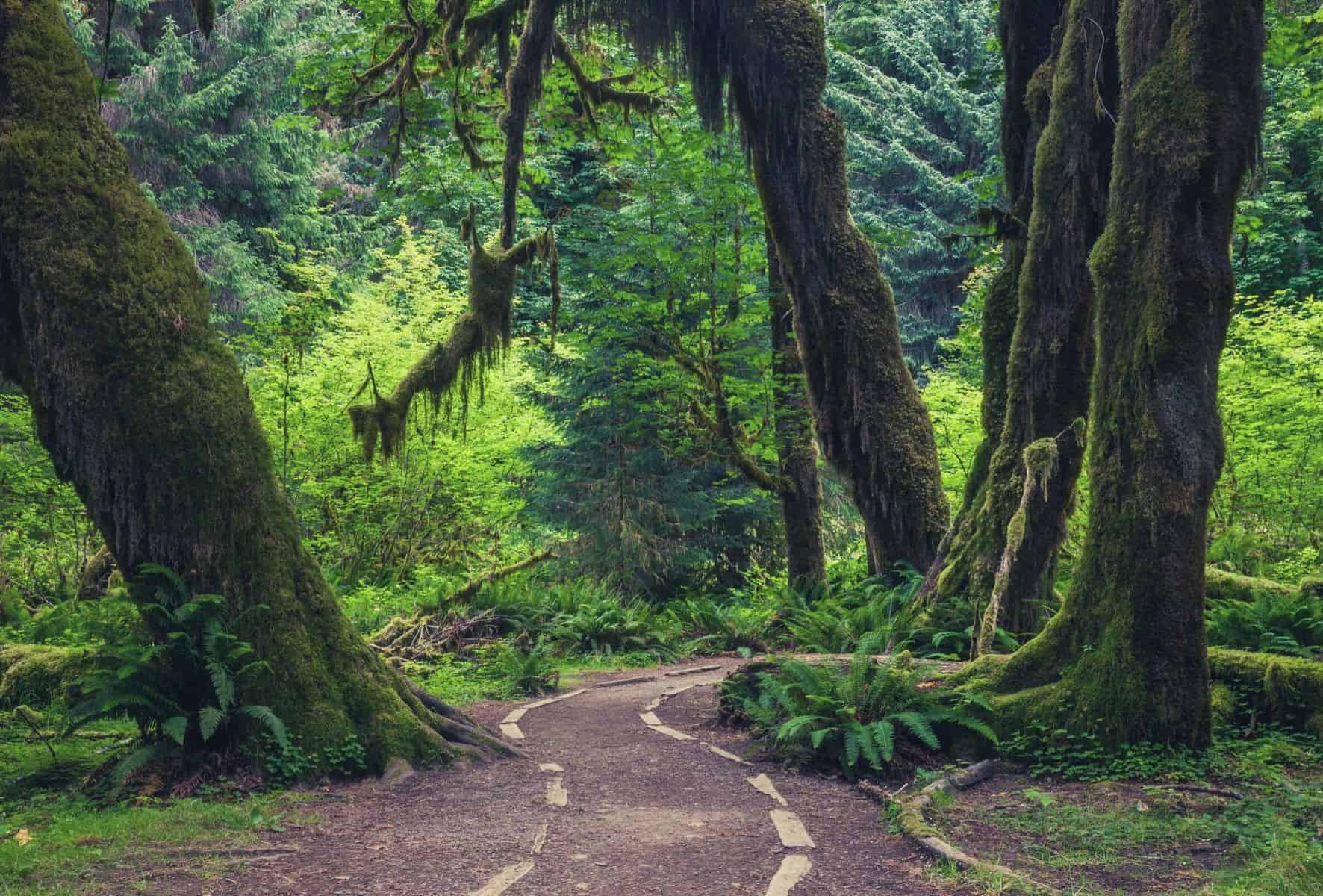
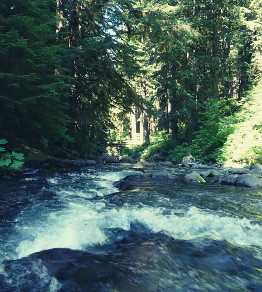
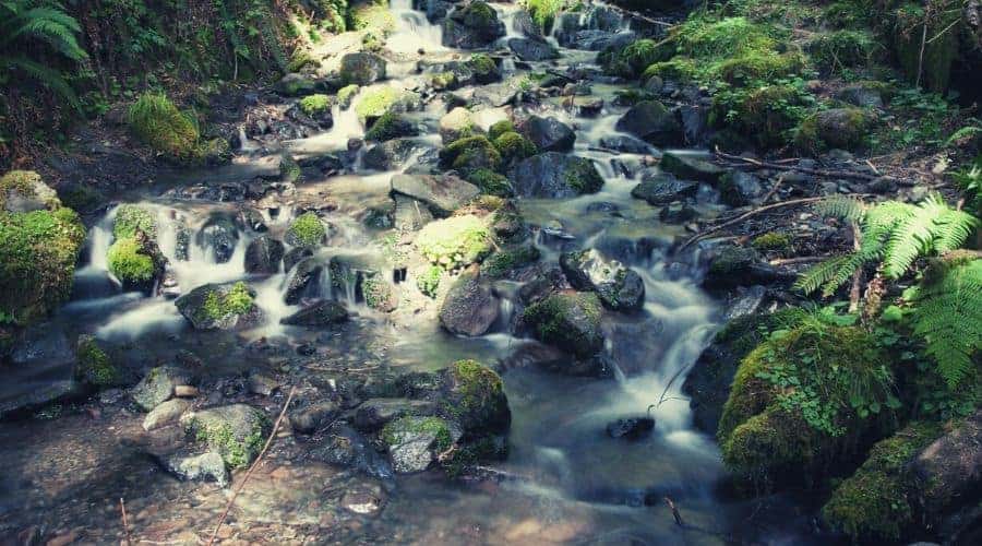
The trail’s early stages snake through the verdant bowels of the Hoh Rainforest, a temperate rainforest that abounds in towering, moss-cloaked coniferous and deciduous trees — including Giant Western hemlock, Douglas fir, Western red cedar, and Sitka spruce — and dense undergrowth.
Dead trunks or branches in the park are left as and where they fall and subsequently become “nurse logs” for other species, thereby adding a further, nutrient-rich substrate from which sprout a host of seedlings, ferns, fungi, and more of the ubiquitous, vibrantly colored moss.
The Blue Glacier
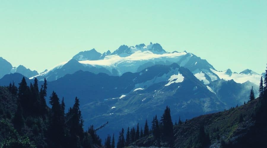
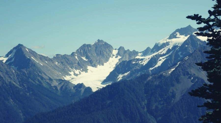
The trail’s second highlight, which you’ll catch your first glimpse of at the trail’s end as a reward for your 17.3-mile effort, is one that often inspires mixed emotions.
Sweeping down the north-west flank of Mount Olympus, The Blue Glacier is undoubtedly an awe-inspiring spectacle, the glistening teals and azures of its numerous crevasses and seracs an eye-catching embellishment on the enormous curtain of white that sweeps down from a shoulder just below the summit itself.
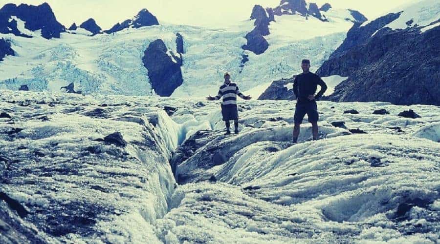
It is not a finale that disappoints, but one that a closer inspection reveals to be in its dotage rather than its youth or zenith. Casting your eye to the towering moraines either side of the glacier, you’ll notice the imprint of a former glacial behemoth, and above them the slender remains of the White Glacier, the steep tongue of which spills over an escarpment to the west.
Knowing that just two centuries ago the Blue and White Glaciers were one and the same, merging at Elk Lake (where many visitors now camp, almost a mile from the glacial terminus), will likely dampen the mood of the more environmentally sensitive visitor. The only consolation comes in having had the chance to see the glaciers in their present splendor, however diminished, before the damage that will inevitably follow in the next 200 years.
Wildlife
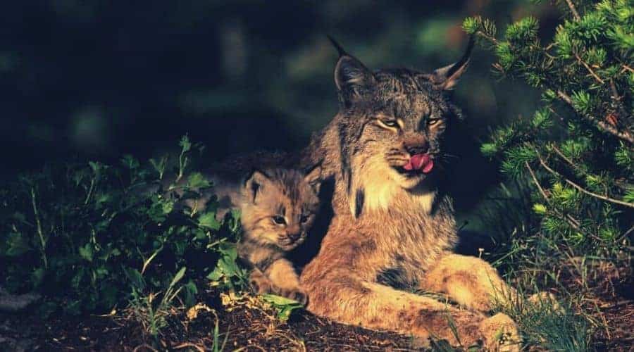
The Hoh River Valley is home to a number of wild critters that add a further element of intrigue and interest to backpackers. The most notable of these include around 400 elk, bears, chipmunks, squirrels, coyotes, martens, Canadian lynxes, Northern pygmy owls, and bald eagles. The Hoh River itself also provides a habitat for various types of salmon, steelhead, and cutthroat trout.
Type of Trail & Trail Difficulty
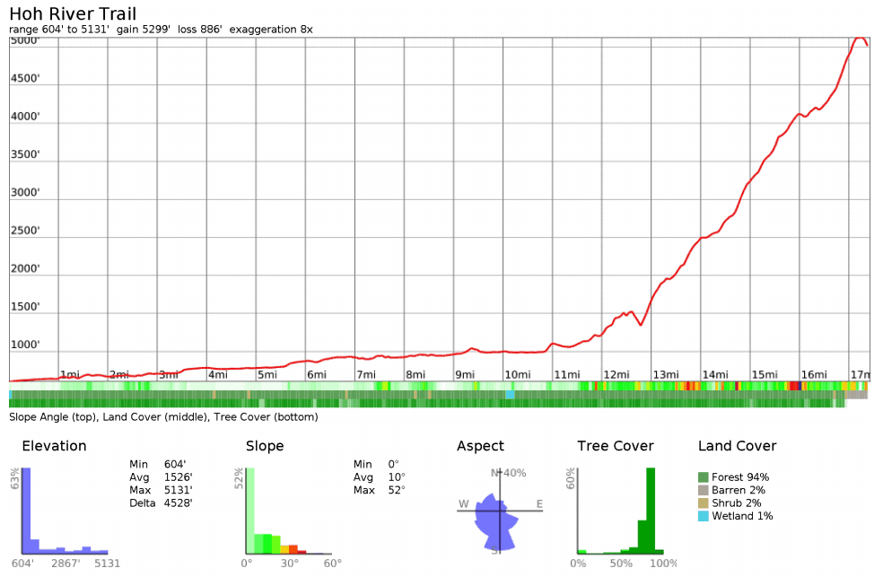
Easy/Moderate out-and-back backpacking trail: 17.4 miles (one way) on relatively flat terrain, with well-maintained and trodden trails and 5,118 feet (1,560m) of ascent over two or three days.
Planning Your Trip
Prior to hiking the Hoh River Trail, hikers are required to take care of a handful of logistical necessities. The good news is that most of these can be done at only one of the Wilderness Information Service centers in the Seattle area, the bad news that — as of yet — online applications are not available.
Campsites
In addition to acquiring a permit, visitors to the Olympic National Park are advised to make reservations for their stay, particularly in peak season (July and August), if you intend on camping in designated quota areas, and/or if traveling in a large group or with stock animals. More information on making reservations for your trip can be found here.
Quota (reservable) campsites include: Ozette Coast (Yellow Banks to Point of the Arches), Royal Basin/Royal Lake, Lake Constance, Upper Lena Lake, Grand and Badger Valleys (all areas from Deer Park to Obstruction Point), Flapjack Lakes, Obstruction Point to Grand Pass, Badger Valley, Lake Lillian, Sol Duc/Seven Lakes Basin/Mink Lake area (includes Cat Basin, High Divide, and Little Divide), Hoh Lake and C.B. Flats, Elk Lake, Martin Creek, and Glacier Meadows.
Best Time to Hike the Trail
Late June to late September. In late summer, the trail is generally at its driest, but those who prefer quiet trails may prefer the shoulder season months of April, May, and October. While doable in winter, the last section of the trail can become very tricky (and tiring) due to snow conditions and is also at risk of avalanche.
Permits
Wilderness Camping Permits are required for all overnight stays in the Olympic National Park wilderness throughout the year. These can be obtained at the following outlets:
- Wilderness Information Center (WIC) in Port Angeles at the Olympic National Park Visitor Center. (*Temporary facilities are located nearby on the front lawn of park headquarters at 600 East Park Avenue.) For inquiries call: (360) 565-3100. Open daily 9am-4pm.
- Quinault Wilderness Information Center at the Pacific Ranger District, Quinault Office,
353 South Shore Rd., Quinault, WA 98575. Phone: (360) 288-0232.
- Staircase Ranger Station in Olympic National Park (at the end of Staircase Road — USFS 24) on the western end of Lake Cushman near Hoodsport, 98548.
Self-Registration Permits for non-quota areas can be obtained after business hours seven days a week. While small hiking parties may get away without making advance reservations, groups or seven or more people should always book in advance. Those 15 years old and younger must be included in group size. During peak season, booking two weeks prior to your visit is recommended. All other sites are available on a first come first served basis.
Trailhead
To reach the Hoh River Trailhead from Port Angeles, drive south on U.S. 101 for 14 miles to the Upper Hoh River Road. Turn left and continue for 18 miles to the Hoh Ranger Station and the trailhead.
Shuttle/Transportation
Hoh River Trail Route
The duration of the Hoh River Trail will depend on a number of factors, including your fitness level, whether you’re a rusher or a relisher, how many pic and pit-stops you make, and, of course, how much time you have on your hands.
The following is an example of a three-day itinerary, which is par for the course for those of moderate fitness levels.
Day One: Hoh River Trailhead to Lewis Meadows (10.5 miles)
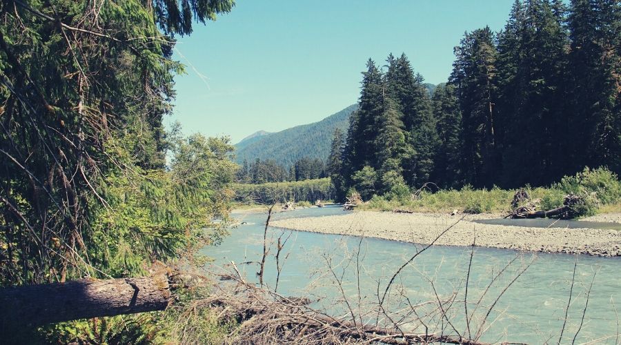
From the Hoh River Trailhead at the Hoh Rainforest Visitor Center area, follow the paved track due east for roughly a quarter of a mile to the junction with the Hoh River Trail. The trail sets off on a very gentle incline along the north flank of the Hoh River and remains relatively level for much of the first 10/11 miles.
About 2.5 miles from the trailhead, the route reaches the Mineral Creek waterfall and then continues along the Hoh River, occasionally deviating further away from the water before veering back. Throughout this section there are a number of small but potentially tricky stream crossings — hiking poles are recommended!
After 5 miles, the trail arrives at the aptly named Five Mile Island, a small meadow and gravel/sand-bar with spectacular views up the valley ahead and to Bogachiel Peak. A further 0.5 miles will take you to Happy Four Camp, where you’ll find a basic wooden shelter ideal for taking cover from rain showers. From here on, the trail is less well-maintained and at times overgrown or spotted with windfall debris and fallen trees.
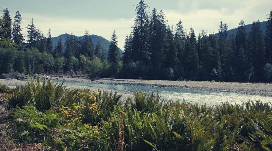
The trail remains fairly flat until the Olympus Guard Station, situated 9.1 miles from the Visitor’s Center. This is a convenient spot to pitch your tent for the night, but by continuing a further 1.4 miles to the smaller campground at Lewis Meadows, you’ll discover views of the surrounding mountains that are slightly more open and impressive.
More eager and speedy hikers may choose to push ahead at this point in order to camp in view of the glacier. The next stage of the hike, however, is its most demanding, and to make sure you arrive in good shape and suitably fresh for the all the pics you’ll be snapping, we’d recommend setting up camp, lapping up the scenery, and setting off early to get worst of the upcoming ascent under your belt before it gets too hot.
Day Two: Lewis Meadows — Blue Glacier — Lewis Meadows (13.8 miles)
Just after Lewis Meadows, the going gets a little more interesting as the trail climbs over 3,000 feet on the final 4.9-miles approach to Blue Glacier Overlook. 2.8 miles past Lewis Meadow Camp, you will reach the High Hoh Bridge, which marks the end of the Hoh Valley proper. From here, only 1.9 miles remain to Elk Lake and the first views of the Blue Glacier and summit dome of Mount Olympus.
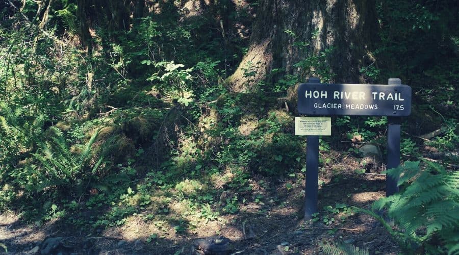
From Elk Lake, the trail climbs sharply to Glacier Meadows, and then veers southward for one mile on fairly loose banks of scree and moraine to the Blue Glacier Overlook. On this section, be particularly careful with your footing and be prepared to stop at least a few times to remove uninvited stones from inside your boots!
At this point, you can either choose to camp at Glacier Meadows and leave yourself a long return journey the following day, or descend back to Lewis Meadows (6.9 miles) or the Olympus Guard Station (8.3 miles), making day three a veritable toddle back to the trailhead.
Day Three: Lewis Meadows to Hoh River Trailhead (10.5 miles)
A simple downhill stroll back to the trailhead (on the same route as the ascent), with a head full of happy memories, oodles of pics to add to your collection, and a chance to enjoy the scenery passed on the way up at a more leisurely pace.
Good to Know
- Groups of more than six must camp in designated group campsites and stock parties in designated stock sites
- Bear wires can be obtained on loan at Tom Creek, Happy Four, 5-Mile Island, Olympus Guard Station, Lewis Meadow, Elk Lake, and Glacier Meadows
- Bear canisters (required for camping on Mount Olympus and in the Sol Duc/Seven Lakes Basin area) are available at the Port Angeles WIC, South Shore Lake Quinault USFS Office, Hoh Visitor Center, and Staircase Ranger Station, but are in limited supply and can run out on busy summer weekends (arrive early to avoid missing out)
- If your food is not properly stored, you may be issued a $50 fine
- Many hikers have been struck down by giardia while hiking the Hoh River Trail — be sure to bring a reliable water purification system
- Campfires are not permitted beyond the Martin Creek campsite (just before Elk Lake)
Suggested Gear List
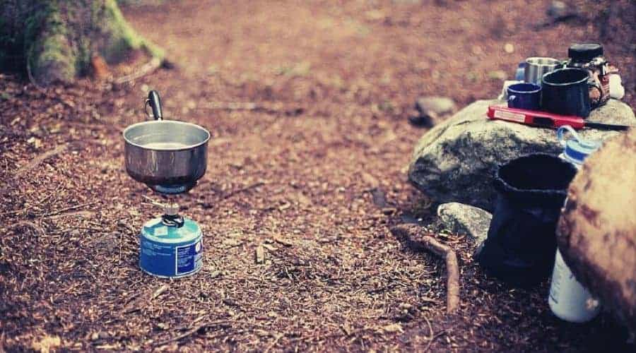
Camping Kit
- Tent (including rain fly)
- Sleeping bag
- Sleeping mat/pad
- Stove and fuel
- Cooking utensils, cutlery, pots
- Camping knife
- Bear canister (available to rent from WIS centers)
- Group bear wire (see food canisters)
Personal
- Hiking boots (boots are preferable to shoes — the trail can be boggy in places and includes a short river crossing)
- Full-length trousers
- Sun-hat (the trail is mainly covered by forest latter sections are more exposed)
- Tick removal kit/tweezers
- Sunscreen
- Water and water filtration/purification kit
- Gaiters if hiking after heavy rainfall
- Bug spray/mosquito repellent
- Bear spray
- First Aid Kit
